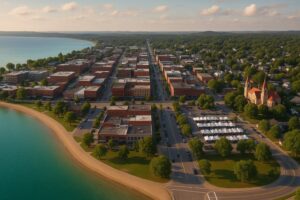
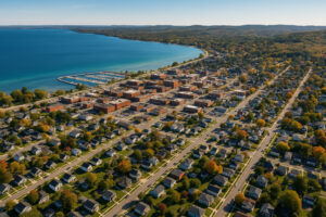
When you first arrive in Traverse City, the city can feel both compact and sprawling. Everything is within reach—downtown shops, Grand Traverse Bay beaches, wineries, and hiking trails—but knowing where things are makes your trip smoother. That’s where a Traverse City map comes in.
To get a fuller picture of the area’s shoreline, explore Grand Traverse Bay’s beaches and boating routes.
💡 Traveler Reflection: The first time I visited, I wandered without a map, assuming I’d figure it out. I missed hidden streets, a tucked-away café, and even the farmers market. On my second trip, I brought a tourist map, and suddenly Traverse City unfolded like a well-marked treasure hunt. Use this map alongside the Ultimate Michigan Coast Travel Guide to explore every hidden gem along Michigan’s coastline.
This guide will serve as your virtual map, breaking down neighborhoods, must-see attractions, and practical travel zones to help you plan your trip like a local.
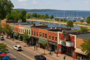
🏙 Downtown Traverse City: The Heart of It All
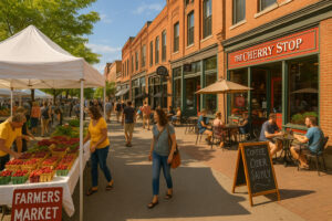
Front Street: The main shopping and dining hub—bookstores, boutiques, coffee shops, and The Outpost.
Clinch Park & Marina: Family-friendly beach and waterfront trails just steps from downtown.
State Theatre: Historic movie house that doubles as a cultural landmark.
Farmers Market: A seasonal favorite for fresh cherries, baked goods, and crafts.
The Traverse City Farmers Market sits right on this map’s downtown grid — ideal for pairing morning shopping with a waterfront lunch.
💡 Traveler Note: I spent an entire day walking just a few blocks of downtown—between bookstores, restaurants, and the waterfront, I never once felt bored.
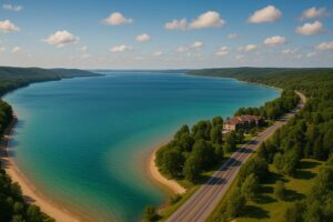
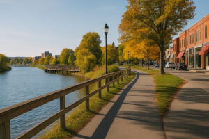
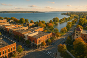
🌊 Grand Traverse Bay
The bay defines Traverse City—splitting into East Bay and West Bay.
West Bay: Closest to downtown, with public beaches, parks, and sunset views.
East Bay: Quieter, with waterfront resorts and family-friendly swimming.
Scenic Drives: Both sides offer stunning routes with lookout points and wineries.
Mark Clinch Park Traverse City on your map—it’s the heart of the waterfront. Trace the shoreline highlights from our Exploring Grand Traverse Bay guide.
💡 Traveler Reflection: Driving along East Bay, I pulled over just to watch the water sparkle—it was like staring at a liquid sapphire.
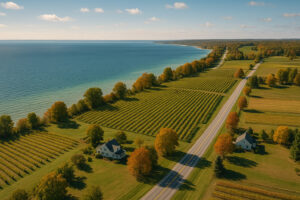
🍇 Old Mission Peninsula
Just north of downtown, the peninsula stretches into Grand Traverse Bay.
Wineries: Famous for Riesling and Chardonnay.
Mission Point Lighthouse: A historic landmark at the tip.
Scenic Roads: Vineyards on one side, bay views on the other.
💡 Traveler Note: My best Traverse City memory is sipping Riesling on a vineyard patio while watching the bay glisten in the distance.
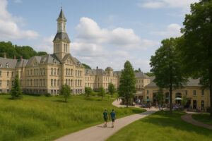
🌲 The Village at Grand Traverse Commons
A blend of history, shopping, and trails.
Historic State Hospital: Explore its preserved buildings and fascinating tours.
Shops & Cafés: Local artisans, restaurants, and wine cellars.
Commons Natural Area: Trails through meadows and forests.
💡 Traveler Reflection: Walking through the Commons felt like stepping into a European village—with a dash of Michigan history.
🧾 Neighborhood Map Snapshot
| Area | Highlights | Best For |
|---|---|---|
| Downtown Traverse City | Front Street, Clinch Park, State Theatre | First-time visitors |
| West Bay | Beaches, marinas, sunsets | Families, couples |
| East Bay | Resorts, quieter beaches | Relaxation seekers |
| Old Mission Peninsula | Wineries, lighthouse, scenic drives | Wine lovers, couples |
| Commons Area | Historic hospital, trails, artisan shops | Culture + outdoors |
🗺 Tourist Map Essentials for Traverse City
Having a Traverse City tourist map is more than a convenience—it’s a survival tool for making the most of your time. Whether you’re walking downtown, biking the TART Trail, or driving up Old Mission Peninsula, knowing the city’s layout saves time and helps you discover spots that most visitors miss.
Explore Neighborhood Map Snapshot on google maps
💡 Traveler Reflection: The moment I unfolded my first Traverse City map, I realized how much I had overlooked—tiny side streets with coffee shops, hidden parks, and shortcuts to the bay.

🚗 Parking & Driving Zones
Downtown Parking: Front Street and nearby lots are metered. Public garages offer daily rates.
Seasonal Crowds: Summer festivals can make parking tough—arrive early.
Residential Streets: Many allow parking within walking distance of downtown.
💡 Traveler Note: I once circled downtown three times during Cherry Festival week before finally finding a spot. Since then, I park a block or two away and enjoy the walk in.
🚶 Walking Trails & Downtown Paths
Traverse City is a walkable city, and a good downtown walking map makes exploring effortless.
Front Street Loop: Perfect for shopping, dining, and waterfront strolls.
Boardwalk at Clinch Park: Connects downtown to the marina and beaches.
Commons Trails: Gentle trails winding behind the historic State Hospital buildings.
💡 Traveler Reflection: My favorite walk was at sunset, from Front Street to Clinch Park—the glow of the bay matched the golden light in shop windows.
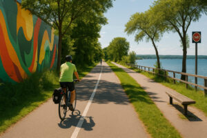
🚴 Biking Routes
The TART Trail (Traverse Area Recreation & Transportation) is a must for cyclists.
Distance: 10.5 miles through downtown and along the bay.
Highlights: Waterfront stretches, art murals, and quiet wooded sections.
Connections: Links to Leelanau Trail for a longer ride through vineyards and countryside.
💡 Traveler Note: I rented a bike and rode the TART Trail one morning—it felt like a fast-track map of Traverse City, from beaches to backstreets in less than an hour.
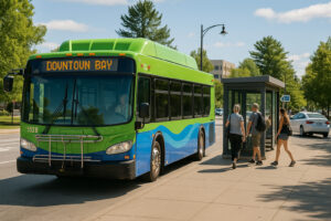
🚌 Public & Visitor Transport
BATA Buses: Local routes connect key parts of the city, including East and West Bays.
Downtown Bayline: Free shuttle looping between downtown, Commons, and bayside.
Taxi & Rideshare: Uber/Lyft available but limited during late nights.
💡 Traveler Reflection: The free Bayline shuttle saved me on a hot summer day when walking felt impossible—it was quick, air-conditioned, and made sightseeing easier.
🗺 Key Zones on a Tourist Map
Downtown Core: Front Street, State Theatre, Clinch Park.
East Side: Cherry Capital Airport, East Bay hotels, quieter beaches.
West Side: West Bay beaches, marinas, and waterfront trails.
North: Old Mission Peninsula wineries, Mission Point Lighthouse.
Southwest: The Commons with historic tours, trails, and artisan shops.
🧾 Tourist Map Snapshot
| Map Feature | What It Shows | Why It Matters |
|---|---|---|
| Parking Zones | Downtown lots, garages, side streets | Avoid circling in crowds |
| Walking Loops | Front Street, Clinch Park paths | Best for short visits |
| Biking Trails | TART Trail, Leelanau Trail connections | Active sightseeing option |
| Transit Lines | Bayline shuttle, BATA routes | Car-free travel possible |
| Neighborhood Zones | Downtown, Bays, Commons, Peninsula | Helps plan itineraries |
💡 Traveler Reflection: My map became a scrapbook—I marked every place I visited, from a café on Front Street to a secret bench by the bay. Looking back at it felt like reliving my Traverse City trip.
🗺 Detailed Neighborhood Maps of Traverse City
When you zoom in closer, Traverse City’s map splits into distinct zones—each with its own character, highlights, and travel rhythm. Think of it like puzzle pieces that fit together to create the whole Traverse City experience.
💡 Traveler Reflection: When I looked at a detailed tourist map, Traverse City stopped feeling like “just a small town” and instead felt like a city of layers—each neighborhood revealing a different mood.
🏙 Downtown Traverse City Map
Highlights:
Front Street: Main artery for shopping, bookstores, and dining.
Clinch Park & Marina: Just steps away from downtown with beach access.
State Theatre & City Opera House: Cultural icons marked clearly on maps.
Farmers Market: Seasonal hub for foodies and artisans.
Pin the downtown Traverse City Farmers Market for local food stops.
💡 Traveler Note: I once traced a downtown map with my finger, hitting a bookstore, an ice cream shop, and the bay—all within a two-block walk.
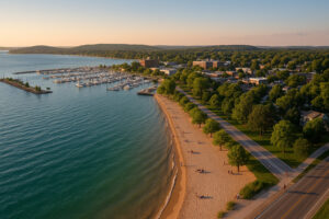
🌊 West Bay & Waterfront Map
The West Bay is the most photographed part of Traverse City.
Key Points on the Map:
Clinch Park Beach: Central beach with a long stretch of sand.
Sunset Points: Marked spots where locals gather for golden-hour views.
Waterfront Trails: Walking and biking paths hugging the shoreline.
Marinas: Boat rentals and docks appear clearly on tourist maps.
Don’t miss Clinch Park on West Bay, the heart of local recreation and summer festivals.
💡 Traveler Reflection: My map led me to a small public pier that wasn’t listed in guidebooks—it became my favorite sunset spot.
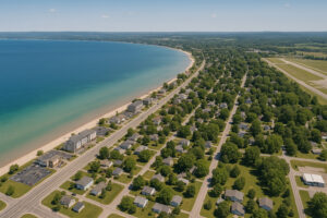
🌊 East Bay Map
The East Bay offers a calmer side of Traverse City.
Map Highlights:
Resort Strip: Hotels and inns along US-31.
Quiet Beaches: Smaller, family-friendly public access points.
East Bay Park: A hidden local favorite.
Cherry Capital Airport: Conveniently mapped just minutes from the bay.
💡 Traveler Note: East Bay looked like just a line of hotels until my map pointed out small public beaches—I ended up finding my own quiet swimming spot.
🍇 Old Mission Peninsula Map
One of the most iconic Traverse City map sections.
Key Stops:
Wineries: Dozens plotted along M-37 and back roads.
Mission Point Lighthouse: The peninsula’s northern tip.
Scenic Pull-Offs: Many maps mark bay-view stops for photo ops.
Hiking Trails: Smaller trails tucked near vineyards.
💡 Traveler Reflection: I followed a wine trail map that led me from one vineyard patio to the next, always with the bay shimmering nearby. It felt like following a treasure map—only the reward was a glass of Riesling.
🌲 The Village at Grand Traverse Commons Map
A mix of history and nature.
Map Features:
Historic State Hospital: Tours begin here—often marked on heritage maps.
Shops & Cafés: Artisan stores plotted within the village complex.
Commons Natural Area: Walking paths winding behind the buildings.
Trailheads: Often mapped for visitors who want to mix shopping with hiking.
💡 Traveler Reflection: My tourist map showed me a shortcut trail behind the Commons that led to a meadow with wildflowers—I’d never have found it otherwise.
🧾 Neighborhood Map Snapshot
| Area | Map Features | Why It Matters |
|---|---|---|
| Downtown | Front Street, Clinch Park, cultural icons | Core of Traverse City life |
| West Bay | Beaches, marinas, sunset points | Scenic + family-friendly |
| East Bay | Resorts, small beaches, airport | Relaxation + accessibility |
| Old Mission Peninsula | Wineries, lighthouse, scenic stops | Wine lovers + road trips |
| Commons | Historic hospital, artisan shops, trails | Culture + nature blend |
💡 Traveler Reflection: The more I studied these detailed maps, the more Traverse City felt like a place I could live in—not just visit.
🗺 Thematic Maps of Traverse City
While a basic tourist map shows streets and landmarks, thematic maps give your trip personality. Whether you’re chasing wine, food, trails, or local secrets, these focused maps help you design an experience that feels tailor-made.
💡 Traveler Reflection: The first time I picked up a Traverse City wine trail map, I realized it wasn’t just paper—it was a plan for one of the best afternoons of my life.
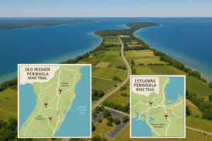
🍷 Traverse City Wine Trail Maps
Traverse City is Michigan’s wine capital, and maps make exploring seamless.
Old Mission Peninsula Wine Trail: Dozens of wineries marked along M-37 and side roads.
Leelanau Peninsula Wine Trail: Nearby, with maps highlighting wine clusters and scenic overlooks.
Highlights: Chateau Chantal, Bowers Harbor Vineyards, Mari Vineyards.
💡 Traveler Note: With a wine trail map in hand, I planned a 3-stop tasting day—each winery within 15 minutes of the last. Without it, I’d have wasted time guessing.
🍒 Foodie & Culinary Maps
Traverse City has a vibrant food scene, and some maps are built around it.
Cherry-Themed Food Map: From pies to salsas, cherry treats are marked across town.
Farm-to-Table Maps: Farmers markets, organic grocers, and restaurants sourcing local.
Brewery & Distillery Maps: Microbreweries, cider houses, and cocktail bars plotted clearly.
💡 Traveler Reflection: A café map led me to a hidden breakfast spot off Front Street—without it, I’d have missed one of the best meals of my trip.
🚴 Hiking & Biking Trail Maps
Outdoor lovers rely on Traverse City’s trail maps.
TART Trail Map: Running through downtown and along the bay.
Leelanau Trail Map: Extends into vineyards and countryside.
Commons Natural Area Maps: Short trails ideal for beginners.
💡 Traveler Note: With my trail map, I biked from downtown all the way to Suttons Bay—it felt like following a secret line through fields, forests, and vineyards.
🎉 Seasonal Event Maps
Traverse City’s biggest events require special maps.
National Cherry Festival Maps: Parade routes, parking zones, festival grounds.
Film Festival Maps: Theaters, screening locations, and shuttle stops.
Winter Maps: Highlight cross-country skiing and snowshoeing trails.
💡 Traveler Reflection: My Cherry Festival map became my guidebook for the week—I knew where to park, where to stand for parades, and where the fireworks would explode over the bay.
Some maps go beyond the usual tourist stops, pointing to Traverse City’s secrets.
Historic Maps: Ghost tours, old churches, and forgotten landmarks.
Local Favorite Spots: Ice cream stands, secret beaches, and offbeat shops.
Photo Maps: Popular Instagram spots and scenic overlooks.
💡 Traveler Note: My favorite discovery came from a “hidden Traverse City” map—a back alley mural that wasn’t in any guidebook.
🧾 Thematic Maps Snapshot
| Theme | Highlights | Best For |
|---|---|---|
| Wine Trails | Old Mission & Leelanau wineries | Couples, wine lovers |
| Foodie Maps | Cherries, breweries, farm-to-table | Foodies, families |
| Hiking/Biking Maps | TART Trail, Leelanau Trail, Commons | Active travelers |
| Event Maps | Cherry Festival, Film Festival | Seasonal visitors |
| Hidden Gems Maps | Ghost tours, murals, local secrets | Explorers, photographers |
💡 Traveler Reflection: Every map I collected became part of my trip journal—wine stains on one, festival stickers on another. They weren’t just guides; they became souvenirs.
🧭 Practical Traveler Map Hacks for Traverse City
A good Traverse City map is more than paper—it’s a strategy tool. Between apps, printable guides, and insider tricks, you can make navigating this city smoother and more enjoyable.
💡 Traveler Reflection: On my first trip, I relied on instinct and missed half of what Traverse City had to offer. By my second trip, I used maps, apps, and locals’ tips—I felt like I knew the city inside out.
📱 Digital Map Apps
Google Maps: Essential for driving routes, winery stops, and restaurant reviews.
AllTrails: Great for hiking and biking around the Commons and peninsula trails.
Transit Apps: Some locals use BATA’s app for public bus routes.
Offline Maps: Download maps before heading into wine country—service can drop on the peninsula.
💡 Traveler Note: My offline Google Map saved me when GPS cut out on Old Mission Peninsula—I still found my winery without stress.
📄 Printable Tourist Maps
Many visitors still prefer paper maps, especially in festival season.
Downtown Visitor Center: Offers free fold-out maps with parking and attractions.
Cherry Festival Map: Parade routes, booths, fireworks zones—all clearly marked.
Winery Trail Maps: Often printed and available at tasting rooms.
💡 Traveler Reflection: My folded paper map from the visitors center became a keepsake—I circled every place I visited, and now it’s like a scrapbook.
🗺 Combining Routes for Maximum Efficiency
Instead of treating each map separately, combine them for smart planning.
Morning Downtown Walk: Use a city map for shops and cafés.
Afternoon Winery Tour: Switch to wine trail maps.
Evening Sunset Drive: Follow bayfront map pull-offs.
Next Day Adventure: Layer hiking and biking trail maps.
💡 Traveler Note: By linking my maps, I did downtown, wineries, and a sunset—all in one day without backtracking.
🔍 Insider Map Strategies
Mark Favorites Early: Circle restaurants or wineries you don’t want to miss.
Use Landmarks: Grand Traverse Bay and Front Street are easy anchors.
Talk to Locals: Clerks often draw “x” marks on maps for hidden favorites.
Keep a Map Journal: Write notes directly on your maps—it becomes a memory log.
💡 Traveler Reflection: A café owner drew an arrow on my paper map to a hidden mural—I’d never have found it otherwise.
🧾 Map Hacks Snapshot
| Hack Type | Example | Why It Helps |
|---|---|---|
| Digital Apps | Google Maps, AllTrails | Accuracy + reviews |
| Printable Maps | Visitor center, festival, winery maps | Offline, easy to mark |
| Route Combining | Downtown + winery + sunset drive | Saves time |
| Insider Tricks | Locals’ map notes, landmark anchors | Hidden gems & stories |
🌟 Final Thoughts: Mapping Traverse City
Maps aren’t just for getting from point A to point B—they’re for discovering Traverse City in layers. From Front Street to Old Mission, from the Commons to East Bay, every map reveals a new side of the city.
The bus was comfortable. Our driver was awesome. I thoroughly enjoyed the five wineries that we went to. It was fun, fun fun and would love to do it again.
💡 Traveler Reflection: By the end of my trip, my maps were covered in notes, stains, and folds. They weren’t just guides—they had become part of my Traverse City story.