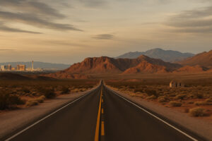
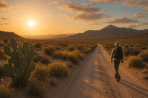
Few journeys capture the soul of the American Southwest quite like a Southern Nevada road trip. From the neon pulse of Las Vegas to the silent horizons near the Arizona border, the landscape changes with every mile — city lights give way to canyons, then to endless desert that feels older than time.
I’ve driven this route many times, and each trip still feels like stepping between centuries. Along this corridor, highways follow wagon roads, and ghost towns whisper behind modern rest stops. It’s not just a drive; it’s a living museum of desert endurance.
For a statewide overview of historic towns, classic hotels, and heritage festivals, see our Historic & Cultural Experiences in Nevada guide.
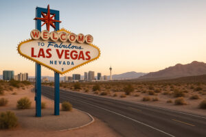
Las Vegas – Where the Journey Begins
A Modern Oasis in the Mojave
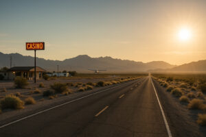
Every Southern Nevada road trip starts beneath the glittering skyline of Las Vegas. But before you rush out of town, take a morning to see what lies behind the Strip’s glamour. The Neon Museum preserves dozens of vintage casino signs, each a monument to Vegas’s boom-and-bust past. A few miles north, the Old Las Vegas Mormon Fort marks the city’s first settlement, built by pioneers in 1855 near a natural spring that still flows today.
If you start early, grab breakfast downtown at Public Us, a local café where travelers mingle with artists and desert climbers. Once you’ve had your caffeine, set your navigation toward Boulder City, roughly 30 miles southeast via U.S. 93 — the first stretch of what many call The Crossroads Highway.
Leaving the City Behind
The highway rolls over pale hills, past construction yards and the last suburban cul-de-sacs before the desert swallows the horizon. Within minutes, the air feels drier, and the light sharpens. Pull over at Railroad Pass, the oldest casino still operating in Nevada and a favorite stop for road-trippers since 1931.
Just beyond the pass, the view opens — a broad valley cupped between red and tan mountains, the Colorado River glimmering in the distance. This is the entrance to Boulder City, a town built for a dam and kept alive by its own sense of purpose.

Boulder City – Built for the Dam and Shaped by History
A Town Born of Courage
When the Hoover Dam project began in 1931, thousands of workers and their families poured into the desert. The government responded by creating Boulder City — a planned community without gambling or bars, designed to house the men who tamed the Colorado River. Nearly a century later, the town remains clean, quiet, and proud of its heritage.
Walk down Wyoming Street and Arizona Street to see original cottages that once belonged to dam engineers. The Boulder City Hoover Dam Museum inside the historic Boulder Dam Hotel tells stories of heat, hard labor, and human ingenuity that turned an idea into one of America’s great engineering marvels.
TripAdvisor reviewers often describe the museum as “small but powerful,” and they’re right — the black-and-white photos of workers dangling from cables will make you pause before driving onto the dam yourself.
I recently stayed at this location, while visiting family that is stationed at Ft. Jackson. The hotel is conveniently located, near good food, and shopping.
Travelers on TripAdvisor call the Boulder City Hoover Dam Museum ‘a small museum with a huge heart,’ praising its storytelling and vintage photos.
Exploring Old-Town Charm
Modern Boulder City mixes heritage with hospitality. Stop for lunch at The Coffee Cup Café, a Route 66-style diner famous for its Hawaiian pork omelet and walls covered in license plates. Wander through antique shops filled with railroad memorabilia, then relax under the shade of Wilbur Square Park where locals host art fairs and vintage car shows.
If you want a panoramic view of the valley, drive a few minutes to the Hemenway Park Overlook — home to a herd of wild bighorn sheep that graze on the grass most mornings. From there, Lake Mead stretches like a blue ribbon to the east.
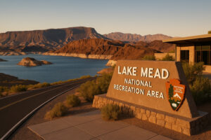
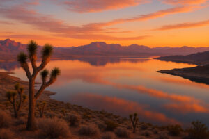
Lake Mead – Where the Desert Meets the Water
From River to Reservoir
The creation of Hoover Dam in 1936 formed Lake Mead, the largest reservoir in the United States. This massive body of water transformed Southern Nevada into a playground for boaters, fishermen, and desert wanderers.
At the Lake Mead Visitor Center, you’ll find maps, exhibits, and rangers happy to share trail conditions and wildlife tips. One TripAdvisor review calls it “the best five-minute education you can get before entering the park.”
Drive the Lakeshore Scenic Byway for glimpses of rugged islands and towering cliffs. You can stop at Boulder Beach for a swim or launch a kayak from Hemenway Harbor. When the sun starts to drop, the light turns copper against the canyon walls — an unforgettable sight for any photographer.
Explore Lake Mead – Where the Desert Meets the Water on Google Maps
A Lesson in Water and Time
Lake Mead’s shoreline tells a story about climate and change. The “bathtub ring” — a white band of mineral-stained rock above the current water level — marks decades of fluctuation. Standing here, you realize how fragile the balance is between human ambition and nature’s limits.
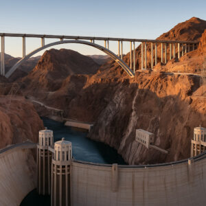
Hoover Dam – Crossroads of Innovation and Imagination
The Monument That Tamed a River
No Southern Nevada road trip is complete without the Hoover Dam. Rising 726 feet above the Colorado River, it’s as awe-inspiring today as it was in 1935. You can walk across the dam between Nevada and Arizona and watch the time change by an hour on your phone as you cross the state line.
Inside the visitor center, turbine tours reveal the massive power plant that still generates electricity for millions. Don’t miss the winged bronze sculptures of Oskar J.W. Hansen — they symbolize the “spirit of human accomplishment.” Each wing is so polished that tourists rub them for luck, keeping the bronze shining decade after decade.
View from the Bypass Bridge
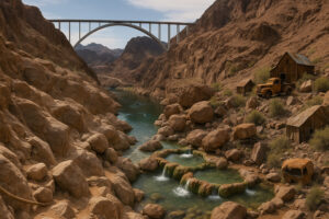
If you prefer a wider perspective, walk onto the Mike O’Callaghan – Pat Tillman Memorial Bridge, completed in 2010. The bridge arcs 900 feet above the river, offering a panorama of the dam and Black Canyon beyond. It’s one of the most photographed spots in Nevada.
Early morning is best; the sun hits the concrete face just as the valley wakes. If you arrive before 8 a.m., you may have the view almost to yourself.
Goldstrike Hot Springs Trail
Just south of the bridge, a dirt road leads to the trailhead for Goldstrike Hot Springs, one of the most remarkable hikes in Southern Nevada. The trail descends through a slot canyon lined with boulders and ropes that guide you down to a series of steaming pools near the Colorado River.
It’s challenging and should only be attempted in cooler months, but the reward is soaking in natural hot springs while watching kayakers float by below. This spot appears frequently in Google Maps reviews as “the hidden gem you earn with sweat.”
Eldorado Canyon and Nelson Ghost Town
A short detour south on U.S. 95 leads to Eldorado Canyon, once one of the wildest mining areas in Nevada. The town of Nelson now hosts a preserved ghost town where weather-beaten barns and rusted vehicles form a photographer’s dreamscape. Tours of the Techatticup Mine reveal tunnels carved in the 1800s and tales of outlaws who hid their loot in these hills.
From the mine, you can see the Colorado River glimmer again — a reminder that all roads in Southern Nevada eventually wind back to water and stone.
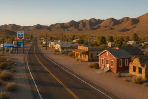
Searchlight – The Crossroads of the Desert
A Town Built on Luck and Persistence
Heading south from Boulder City along U.S. 95, the road narrows into rolling hills and desert plains that shimmer in the sunlight. Forty miles later, the landscape opens again — and the small town of Searchlight appears like a mirage.
Founded in 1897, Searchlight once had more than 1,500 residents and even outshone Las Vegas in mining output. Today it’s a quiet stopover, where gas stations double as museums and conversation comes easily. One TripAdvisor reviewer calls it “the most peaceful forgotten town in Nevada.” Extend your route north with our historic drives between Reno and Las Vegas to discover even more frontier towns. Make a stop in the past by exploring vintage casinos and Las Vegas history for classic architecture and mid-century glamour. If you’re planning this journey during quieter months, see our guide to the best off-season destinations in the USA.
Stop by the Searchlight Historic Museum, a small but fascinating collection of mining tools, photographs, and local memorabilia. There’s also a small exhibit dedicated to U.S. Senator Harry Reid, who grew up here when Searchlight was little more than a dusty mining camp.
Explore Searchlight – The Crossroads of the Desert on Google Maps
Desert Stops and Stories
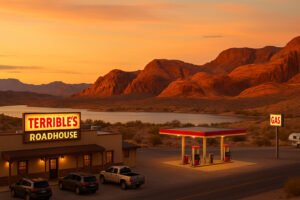
Behind the Chevron station sits the Nugget Casino, one of Nevada’s smallest, with a single row of slot machines. Grab a burger at Terrible’s Roadhouse Diner, where truckers swap stories about mirages and desert storms. Locals might tell you that Searchlight’s nights are so dark you can see the Milky Way like spilled sugar across the sky.
If you take the time to walk behind the town, a short dirt trail leads to remnants of the old Quartette Mine — foundations and rusted ore carts surrounded by creosote bushes. The quiet hum of the wind feels timeless.
From Searchlight to Laughlin – Following the Colorado River
Highway to the River
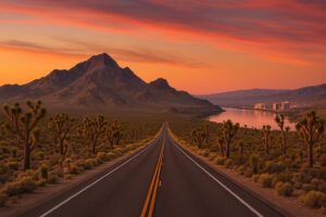
From Searchlight, head southeast on State Route 164, known as the Joshua Tree Highway. This 30-mile route winds through one of Nevada’s most scenic desert corridors, dotted with thousands of Joshua trees stretching toward the horizon.
There are no towns between here and Laughlin, but there are dozens of places to pull over and feel the scale of the Mojave. The best stop is Spirit Mountain Wilderness Overlook, where the peaks rise like ancient sentinels. According to Mojave and Paiute oral tradition, this mountain is sacred — the place where life began. Respect the silence; it feels like the desert itself is speaking.
Arrival in Laughlin
Descending toward the Colorado River, the air warms, and the first casino lights appear. Laughlin may look like a smaller cousin to Las Vegas, but it has a charm all its own. It began in the 1960s when entrepreneur Don Laughlin built a small riverside motel and ferry dock. Today it’s a full-fledged resort town, with riverwalks, steamboats, and nightlife that feels pleasantly unhurried.
Walk along the Laughlin Riverwalk, especially at sunset, when the water glows orange and the casinos reflect in its surface. If you want a break from the road, book a short Colorado River Cruise — a one-hour round trip that floats between Laughlin and Davis Dam, offering a different view of the desert’s quiet beauty.
We took this tour as a part of a guided trip in New England. The State House Tour was great! It was nice to see all the branches of the House and our guide Nick was both knowledgable and enthusiastic to share.
The Laughlin Riverwalk earns glowing reviews for sunset views and peaceful river cruises.
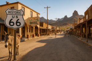
Oatman – Donkeys, Gold, and Old Route 66
Crossing the State Line
From Laughlin, cross the bridge into Arizona and follow Historic Route 66 toward Oatman, a living ghost town with a personality all its own. While technically outside Nevada’s border, nearly every Southern Nevada road trip includes Oatman — the line between states here is more symbolic than real.
Oatman was a booming gold-mining camp in 1915, home to thousands and visited by movie stars like Clark Gable and Carole Lombard. Today, burros — descendants of miners’ pack animals — wander freely through the streets. Locals sell “burro food” to tourists, and the animals have learned to pose for photos like seasoned performers.
Main Street in Time’s Shadow
Step into the Oatman Hotel, one of Arizona’s oldest continuously operating inns, where visitors can still see the honeymoon suite of Gable and Lombard. The wallpaper is covered in dollar bills signed by travelers from around the world — a quirky tradition that began decades ago.
The drive up and over Sitgreaves Pass afterward is narrow and winding, offering some of the best panoramic views in the region. It’s a place where you can literally see history spread out in the folds of the desert below.
Back to Nevada – Cal-Nev-Ari and the Loneliest Highways
A Town with Three States in Its Name
Returning north from Oatman, follow the road back into Nevada and make a stop at Cal-Nev-Ari — one of the smallest incorporated towns in America. Its name stands for California-Nevada-Arizona, a nod to its location near the borders of all three.
The town was founded in 1965 by a pilot couple who built an airstrip, café, and homes for fellow aviators. Today, the runway still operates, and visitors can watch small planes land beside the desert highway. The Cal-Nev-Ari Casino is a single low building with a glowing sign and a friendly bartender who might share tales of dust storms and lost treasure mines.
The Loneliest Beauty
Continuing north, you rejoin U.S. 95 toward Henderson or detour west toward Searchlight Junction and El Dorado Valley. These roads may not have billboards or attractions, but that’s their magic. The horizon stretches endlessly, and the silence feels absolute.
Pull over once in a while and simply listen — no cars, no people, just the sound of the wind brushing the desert grass. It’s the same silence pioneers heard more than a century ago.
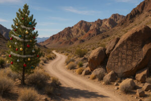
Christmas Tree Pass
A detour worth every minute is Christmas Tree Pass, located off U.S. 93 near Laughlin. The gravel road climbs through colorful cliffs and petroglyph sites, connecting the Colorado River Valley to Searchlight. Travelers often decorate one desert pine with tinsel and ornaments — a spontaneous tradition that adds a touch of humor to the harsh landscape.
Stop at Grapevine Canyon, part of the Spirit Mountain Wilderness, to see ancient petroglyphs etched into the rocks. Archaeologists believe they’re over 800 years old, marking this canyon as a sacred site for native peoples. Be respectful; these markings are irreplaceable.
If you missed it earlier, another must-see is the Nelson Ghost Town near Eldorado Canyon. It’s one of the most photographed locations in the entire Southwest, often used in music videos and movies. The drive there from Searchlight is short and filled with dramatic ridgelines and dry washes that glow gold in the afternoon light.
Refueling and Rest
The desert may seem empty, but good food and shelter are never far.
Laughlin: Riverside Resort Hotel & Casino – comfortable rooms overlooking the river.
Boulder City: Milo’s Cellar – local wine bar with cozy lodging attached.
Searchlight: Terrible’s Roadhouse – not fancy, but the burgers are unbeatable after a long day.
If camping is more your style, Lake Mead National Recreation Area has well-kept campgrounds at Boulder Beach and Willow Beach, both offering starlit nights and early morning views worth waking up for.
Valley of Fire – Nevada’s Red Kingdom
Entering a World of Stone and Flame
Leaving the southern desert behind, follow Interstate 15 north from Las Vegas for about an hour and take the exit for Valley of Fire State Park. The road alone feels cinematic — curving through sandstone waves that shimmer crimson under the desert sun. It’s the oldest and one of the most stunning state parks in Nevada, and no Southern Nevada road trip is complete without it.
The name comes from how the cliffs ignite with color at sunrise and sunset. I remember arriving just before dusk and watching the rocks glow as if the valley were alive. The air smelled faintly of creosote and dust — the scent of deep time.
Explore Valley of Fire – Nevada’s Red Kingdom on Google Maps
Exploring the Valley
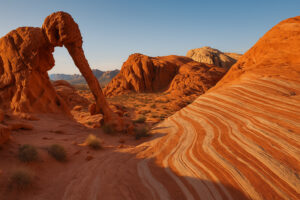
Valley of Fire offers a dozen trails, each revealing something different about the desert’s character. The short hike to Elephant Rock leads to a natural arch shaped like its namesake, while Fire Wave Trail winds through striped stone swirls that look painted by hand. The longer White Domes Loop passes slot canyons and old film sets where Hollywood once staged its Western dreams.
Don’t miss Atlatl Rock, where ancient petroglyphs depict hunters and bighorn sheep — reminders that people have lived in this harsh beauty for more than 2,000 years. Standing there, tracing the symbols with your eyes, you feel the same pull that has drawn travelers across Nevada for millennia.
Do not hesitate to discover in addition to the Strip the historic center of Las Vegas, where it all began!!… A street full of surprises, street shows, shops and a place more “intimate” than the Strip..
Travelers consistently rate Valley of Fire State Park as Nevada’s most breathtaking drive, especially at sunrise.

Mesquite – Where Desert Meets River
A Final Stop Before Utah
Continue northeast on I-15 and you’ll reach Mesquite, a small resort town near the Arizona and Utah borders. It’s often called the “last stop in Nevada” — a crossroads between the Mojave Desert and the red-rock canyons beyond.
Mesquite began as a Mormon farming settlement in 1880, but today it blends golf courses, casinos, and history museums with laid-back desert life. Visit the Virgin Valley Heritage Museum to see pioneer wagons and early homesteading tools. A few miles west lies Little Finland, a hidden plateau of orange sandstone spires that look like coral frozen in rock.
Relaxing After the Road
After days of desert driving, Mesquite feels like a well-earned rest. The CasaBlanca Resort offers comfortable rooms and a pool surrounded by palm trees — a fitting finale to your journey. Dine at Katherine’s Steakhouse, known for seafood flown in fresh despite the desert setting, or grab breakfast at Peggy Sue’s, a retro diner full of Route 66 nostalgia.
In the evening, walk along the Virgin River wetlands trail. The sunset turns the water to gold, and the last light slides across the mountains like a promise of return.
Stayed here for a second time while visiting Mesquite. Very nice clean rooms, nice pool area and a great casino with plenty of restaurant options. Unlike Vegas rooms, there is a refrigerator in the room, so Walmart is not far away to get cheap snack and beverages.
According to TripAdvisor, the Virgin Valley Heritage Museum is a gem for understanding how settlers thrived in the desert.
Practical Travel Tips
Best Time for a Southern Nevada Road Trip
Spring (March–May): Wildflowers bloom across the desert; temperatures are pleasant.
Fall (September–November): Clear skies and cooler weather for hiking and exploring.
Summer: Can exceed 110°F — travel early morning or late afternoon and stay hydrated.
Winter: Crisp air, fewer crowds, and the chance to see snow dusting the distant peaks.
Essentials to Pack
Plenty of water (at least one gallon per person per day)
Sun protection: hat, sunscreen, sunglasses
Printed map or GPS download — cell service fades fast in the Mojave
Snacks, extra fuel, and a flashlight
Camera with spare batteries — sunsets here demand photos
Safety and Respect
Stay on marked roads and trails, and never enter abandoned mine shafts. Carry extra water for emergencies and let someone know your route. Respect petroglyph sites and historic ruins — they belong to all generations of travelers.
Reflections – What the Desert Teaches
Every time I drive these roads, I’m reminded that Nevada’s deserts aren’t empty — they’re full of memory. You sense it in the ruins of mining camps, in the wind that hums through Joshua trees, and in the quiet glow of Lake Mead at sunset.
A Southern Nevada road trip is not just about distance. It’s about perspective. You begin among bright casino lights and end under skies so vast they make the world feel both ancient and new.
Some travelers come for adventure, others for escape, but everyone leaves with the same thought: this place stays with you. Long after you’ve washed the desert dust from your car, you’ll still hear the echo of those wide, endless miles.
Frequently Asked Questions About the Southern Nevada Road Trip
You can complete the main loop in 3–4 days, or stretch it to a week to explore ghost towns, hot springs, and hiking trails at a slower pace.
Las Vegas is the easiest entry, with major car rentals and immediate access to U.S. 93 and U.S. 95 leading toward Boulder City and Searchlight.
Yes. Most routes are paved, but some ghost town detours require a high-clearance vehicle. Check weather conditions before heading off pavement.
Yes, but it makes for a long day. Start early in Boulder City and end with sunset photography at Valley of Fire before returning to Las Vegas.
The Joshua Tree Highway, Lake Mead Scenic Byway, and Valley of Fire Road are all top choices for stunning desert views.
Yes. Lake Mead National Recreation Area, Valley of Fire State Park, and several BLM sites near Searchlight and Nelson allow camping with permits.
Yes. Nelson and Eldorado Canyon are the most accessible and photogenic. Both offer guided mine tours and film-worthy scenery.
Christmas Tree Pass — a quiet, scenic detour connecting Laughlin and Searchlight with ancient petroglyphs and desert solitude.
About 80 miles northeast via Interstate 15 — roughly a 90-minute drive.
Because it connects everything that defines the state — cities, rivers, mountains, ghost towns, and endless desert — in one unforgettable loop.