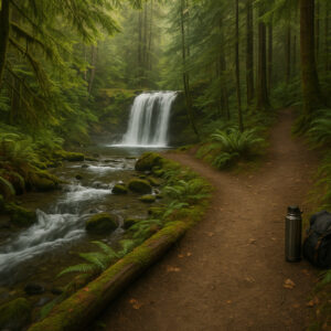
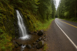
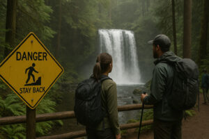
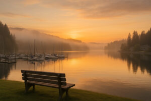
When you first arrive in Port Ludlow, it’s easy to fall in love with its calm marina and quiet forested hills. Yet just beyond that calm lies another world — a world shaped by motion, by the constant rush of water falling through green canyons and mist-covered woods. The hidden waterfalls near Port Ludlow are among the most beautiful, unpublicized treasures of the Olympic Peninsula, and exploring them feels like uncovering a secret written by nature itself.
These aren’t the crowded falls you’ll find in travel brochures or tour guides. Many are tucked behind cedar groves, reached only by narrow paths that weave through fern and moss. Others appear beside the road with no sign to announce them — just the sudden flash of water between trees. Each one has its own rhythm, its own voice, and together they create a portrait of the land that defines this region: wild, generous, and alive.
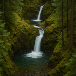
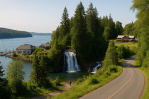
From the gentle cascade of Ludlow Falls, hidden right inside town, to the towering spray of Rocky Brook Falls near Brinnon, these waterfalls remind you how water shapes everything here — from the forests to the people who live beside them. The creeks that feed them are part of an ancient network flowing from the Olympic Mountains down to Hood Canal, threading through small towns, farms, and untouched wilderness along the way.
Why Waterfalls Matter Here
There’s something about waterfalls that captures the essence of the Pacific Northwest better than anything else. Maybe it’s the sound — that endless, cleansing roar that seems to echo from deep time. Or maybe it’s how they reflect the peninsula’s dual nature: calm from afar, but full of untamed power up close.
In Port Ludlow, the surrounding geography makes waterfalls both abundant and hidden. Rainfall from the Olympic Mountains funnels through steep ravines and forest valleys, creating hundreds of small cascades that surge in spring and mellow into silver ribbons by late summer. Many remain unnamed, tucked away on forest lands and private reserves. Yet a handful are accessible for those willing to explore beyond the main roads.
Unlike other parts of Washington, the falls around Port Ludlow feel intimate. They aren’t about size — they’re about mood. You’ll find places where sunlight filters through mist, where moss glows like emerald velvet, and where the air itself feels ancient. These are spots made for quiet awe, not quick photos.
One of the greatest joys of staying in Port Ludlow is how easy it is to reach the rest of the Olympic Peninsula’s waterfall corridor. Within an hour’s drive, you can trace a route that passes through the foothills of the Olympic National Forest, across river valleys, and into canyons carved by rain and time.
Each direction holds a different kind of wonder:
North toward Port Townsend and Chimacum: Short forest walks to lesser-known creeks and microfalls like Beaver Valley Falls.
West toward Dosewallips and Brinnon: Larger, more dramatic waterfalls, including Rocky Brook Falls and Falls View Canyon, where thunderous cascades cut through mossy gorges.
South toward Teal Lake and Anderson Lake State Park: Gentle seasonal streams that come alive in spring rain, perfect for peaceful wanderers.
Whether you’re an experienced hiker chasing hidden gems or a casual traveler seeking a short, scenic stop, Port Ludlow places you within easy reach of it all.
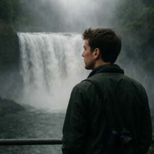
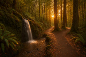
Exploring hidden waterfalls is unlike any other kind of travel. It’s less about destination and more about discovery. You follow the sound before you see it. You notice the shift in air — cooler, damper, electric with motion — before the water comes into view. The first glimpse is always a surprise: a flicker of white through green, a shimmer of spray catching sunlight, the pulse of movement that turns a quiet walk into a moment of wonder.
What makes these places magical is how they demand presence. You can’t rush a waterfall. You have to stand there, breathing in the mist, letting the roar drown out thought. Around Port Ludlow, that sense of stillness is magnified by solitude — chances are, you’ll have the falls to yourself.
These are trails where shoes get muddy, where rain beads on your jacket, where the world slows down until it’s just you and water, moving together in rhythm.
Best Way to Begin
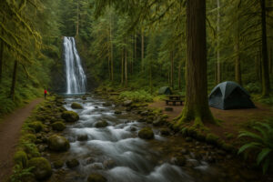
If you’re new to exploring the peninsula, start small and close. Ludlow Falls, located right in the village, is the perfect first step — a local treasure hidden behind forest shade. From there, expand outward: Beaver Valley Falls for peace, Murhut Falls for adventure, Rocky Brook Falls for drama.
Each waterfall in this guide is reachable within a half- or full-day trip from Port Ludlow. Most require only moderate hiking; some need just a short walk from the car. None demand rushing.
To get the most out of your visit, bring:
Waterproof boots or shoes — expect mud and slick rocks.
A light rain jacket — showers can surprise you even on sunny days.
A thermos of coffee or tea — few things taste better beside a waterfall.
A camera or journal — to capture what words might not.
More than gear, bring curiosity. Many of these places don’t appear on standard maps, and sometimes the best discoveries come from asking locals at a café or marina, “Is there a little waterfall nearby worth seeing?”
You’ll be amazed at the answers.
Sustainability and Respect
The hidden waterfalls around Port Ludlow exist in delicate ecosystems. Their beauty depends on the balance of clean water, undisturbed soil, and native vegetation. That’s why local hikers follow a simple rule: “Leave it wilder than you found it.”
Stay on marked paths where they exist. Avoid trampling moss or stepping onto slick rocks near the base of falls. Don’t carve names or stack stones — let the landscape speak for itself.
These small courtesies keep the magic alive, ensuring that every future traveler can experience the same sense of discovery.
The Journey Ahead
Over the next sections, we’ll trace a path from Ludlow Falls, the quiet cascade hidden in town, through forest valleys, rivers, and mountain edges. You’ll meet Beaver Valley Falls, Falls View Canyon, and Murhut Falls — each one with its own rhythm and setting. We’ll end with reflections on how these waterways shape the identity of Port Ludlow and the Olympic Peninsula as a whole.
As you read, imagine the sound of falling water in your mind — steady, constant, pure. It’s the heartbeat of this land, and once you’ve heard it, it never quite leaves you.
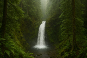
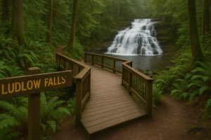
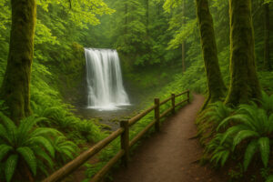
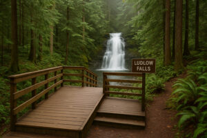
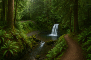
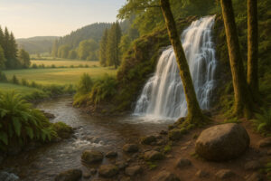
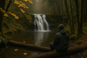
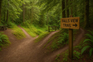
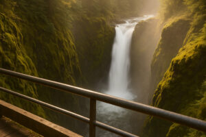
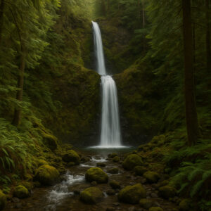
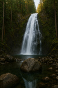
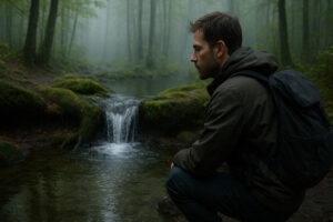
If there’s one waterfall that truly defines Port Ludlow, it’s the one hiding right under everyone’s nose. Ludlow Falls isn’t massive, loud, or hard to reach. In fact, it sits quietly behind the golf course and marina neighborhoods, so close that many visitors don’t even realize it exists. Yet for locals, it’s the soul of the community — a reminder that even in comfort and calm, nature continues to speak softly through the forest.
The moment you step onto the Ludlow Falls Interpretive Trail, you feel that shift — from suburban stillness to forest hush. The short, shaded path leads downhill, and the hum of cars fades quickly behind you. Within minutes, the air turns cooler and wetter. The scent of cedar and earth grows stronger. Then, through a veil of leaves, you hear it: the rhythmic rush of water tumbling down rock ledges — steady, ancient, alive.
A Secret at the Edge of Town
Located just off Teal Lake Road, Ludlow Falls is one of the easiest natural wonders to reach in all of Jefferson County. The trail begins near a small parking area behind the Bay Club, clearly marked by a wooden sign that almost looks too humble for what lies ahead.
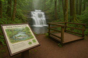
The path itself is short — barely half a mile round-trip — but every step feels like a small descent into another world. Wooden boardwalks curve through fern-covered slopes, and interpretive signs explain the area’s ecology, from salmon migration to the role of native plants in soil health.
Then, just around a bend, the forest opens, and you’re standing on a viewing deck overlooking the falls.
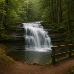
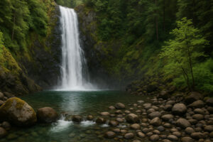
The waterfall spills gracefully over a series of rocky terraces, not in a single plunge but in a layered cascade that fans out like ribbons. During spring and early summer, when rain is plentiful, the flow is powerful — mist rises from the base and paints the leaves in dew. In late summer, it softens into a delicate sheet of silver, slow and meditative.
Seasons of Ludlow Falls
Each season transforms Ludlow Falls into something new.
Spring: The surrounding forest glows with emerald brightness. Ferns unfurl beside the path, and wildflowers bloom along the trail edges. The waterfall runs at its fullest, a symbol of renewal and energy.
Summer: Sunlight filters through high canopies, scattering gold across the water. It’s the perfect time to visit if you prefer warmth and easy footing, though expect a gentler flow and clearer pools below.
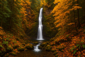
Autumn: Fallen maple leaves gather on wet rocks, creating patches of red and orange around the cascade. The air smells of rain and pine, and the falls take on a soft, steady rhythm.
Winter: Mists roll through the trees, and the water takes on a silvery-gray tone. It’s quieter, colder, but deeply atmospheric — a time for photographers and solitude seekers.
No matter when you visit, Ludlow Falls rewards patience. Standing there, you can hear the constant dialogue between water and stone, the sound deep enough to quiet thought.
Ecology and Local Stewardship
The area around Ludlow Falls is part of Port Ludlow’s greenbelt — a network of protected forest corridors maintained by local volunteers. The trail and viewing platforms are built to protect fragile groundcover and ensure the site remains accessible without disturbing the ecosystem.
Interpretive panels describe how salmon once traveled up nearby creeks, and how the falls mark a natural barrier in their migration. The surrounding forest is rich with western red cedar, Douglas fir, and bigleaf maple, providing critical shade that keeps the stream water cool.
Local groups such as the Port Ludlow Trails Committee regularly maintain this area, clearing debris and repairing bridges after storms. Their work ensures that even as the community grows, the heart of the forest remains undisturbed.
For travelers, this stewardship offers an important reminder: the best natural wonders often endure because people care for them quietly, year after year.
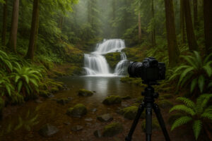
Photography Tips
Ludlow Falls might be modest in size, but it’s a dream for photographers who appreciate texture and tone.
Bring a tripod: The shaded forest allows for long exposures, perfect for capturing the waterfall’s silky flow.
Shoot early morning: The light filters gently through trees, adding soft highlights without glare.
Use a polarizing filter: It reduces surface reflection and enhances the green of moss and ferns.
Experiment with detail: The rocks and leaves near the falls create miniature landscapes worth exploring.
If you visit after rainfall, you’ll find the area alive with reflection — puddles mirror branches, and the air itself shimmers with suspended mist.
A Place for Reflection, Not Rush
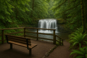
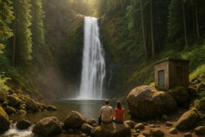
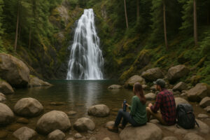
Unlike most tourist waterfalls, Ludlow Falls invites you to linger. There’s a bench near the viewing deck where you can sit quietly, watching droplets arc through the air. You’ll notice how birds return to the branches after a while, how the forest seems to breathe in rhythm with the water.
For locals, this spot is often where they come to think — a place for decisions, for small moments of peace, or simply for gratitude. Many say it’s their “five-minute vacation,” a reminder that tranquility doesn’t always require distance.
You can feel that truth in every sound — the gentle splash of falling water, the rustle of leaves, the murmur of unseen streams that feed into this one. It’s a kind of natural meditation, one that asks for nothing but attention.
How to Visit Ludlow Falls
Trailhead: End of Breaker Lane (behind the Bay Club, Port Ludlow).
Trail Length: 0.3 miles one way (0.6 round trip).
Difficulty: Easy. Wooden stairs and boardwalks make it family-friendly.
Parking: Limited; small gravel lot near the entrance.
Time Required: 20–30 minutes (allow longer if you plan to sit and enjoy the view).
Accessibility: Moderate — the trail includes stairs but is well-maintained.
From the marina area, it’s just a few minutes by car or a pleasant walk through residential lanes surrounded by fir trees and gardens.
Beyond the Falls
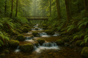
For many travelers, Ludlow Falls becomes the start of something larger. The forest path continues past the main viewing platform, linking to sections of the Port Ludlow Trail System, which weaves over 30 miles through nearby woodland and ridgelines. You can connect your visit here with hikes toward Teal Lake, Beach Club Trail, or Olympic Terrace Loop.
Each route offers glimpses of small unnamed streams that sparkle like threads between ferns — miniature waterfalls in their own right. These hidden flows remind you that water is everywhere here, moving quietly beneath roots and across stone, shaping the land one drop at a time.

A Local’s Perspective
One afternoon, I met a retired teacher sitting on the bench near the viewing deck. She said she walks to Ludlow Falls every morning after breakfast. When I asked why, she smiled and said, “Because it’s honest. It never tries to impress — it just keeps flowing.”
That stayed with me. In a world full of noise and spectacle, Ludlow Falls feels refreshingly humble. It doesn’t roar like Yosemite or tower like Multnomah. It simply exists, content in its own rhythm. And maybe that’s why it resonates so deeply — because it reminds us that beauty doesn’t need to be grand to be profound.
In the Larger Story
As we journey deeper into this guide, you’ll see how Ludlow Falls connects symbolically to the region’s other cascades — each one carrying a fragment of the same story: water descending from the high Olympic ridges to the saltwater bays below.
From here, our path moves outward — to Beaver Valley Falls, a little-known gem tucked between farms and forest, where the same currents that pass through Ludlow eventually find new shapes and songs.
But before leaving this small waterfall behind, take one more look. The water that slips past your feet here is part of the same journey that feeds the canal, the lakes, and the sea. You are standing, quite literally, at the heartbeat of Port Ludlow.
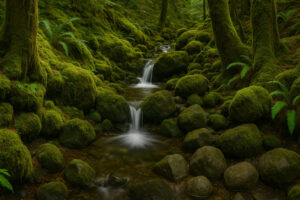
Beaver Valley Falls – The Locals’ Secret
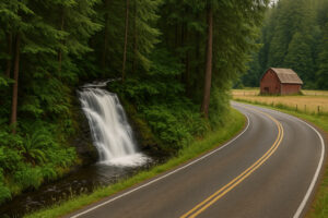
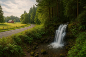
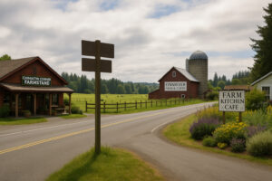
Drive fifteen minutes south from Port Ludlow and you’ll find yourself following a ribbon of two-lane highway through rolling farmland, red barns, and pastures edged with alder and maple. This is Beaver Valley, a landscape that feels suspended in time — quiet, open, and deeply rooted in the rhythms of rural Washington. Somewhere between Chimacum and Coyle, hidden behind a curtain of evergreens and roadside brush, lies a small cascade known only to those who take the time to stop and listen.
Locals call it Beaver Valley Falls, though you won’t see any signs pointing the way. It’s one of those places that exists more in conversation than in guidebooks — the kind of spot you learn about from someone at the farmers’ market or a barista who smiles and says, “Take the road past the old red barn, you’ll hear it before you see it.”
The approach to Beaver Valley Falls begins off Center Road, a scenic route lined with horse fences and weathered silos. About halfway between Chimacum and Coyle Cutoff Road, a narrow gravel pull-off appears beside a stand of cedars. From there, a faint trail slopes down toward the sound of running water.
At first, it feels unremarkable — a small creek winding through ferns. But as you continue down, the sound deepens, gathering power. Then suddenly, the trees open, and a slender waterfall drops about twenty feet over moss-covered rock into a clear pool below. The air turns cool and damp, alive with the scent of cedar sap and mineral mist.
No rails, no platforms, no paved paths — just nature, pure and unscripted.
The Character of Beaver Valley Falls
This waterfall isn’t dramatic; it’s personal. Instead of a single plunge, the water cascades over a tiered ledge, splitting into thin silver threads before merging again at the base. In early spring, when snowmelt from the Olympic foothills rushes through the valley, the falls surge with life, spraying fine mist into the forest. By midsummer, the flow softens into ribbons that sparkle through the branches like strings of glass beads.
The pool below reflects whatever the season brings — autumn leaves drifting on its surface, or the pale light of winter afternoons filtering through bare limbs. Every visit feels different, shaped by weather, light, and sound.
A Quiet Place Between Forest and Farm
What makes Beaver Valley Falls unique isn’t just its beauty but its setting. It sits where farmland meets forest — a boundary that defines much of Jefferson County’s charm. On one side, open fields stretch toward Chimacum Valley’s organic farms; on the other, thick evergreens climb the slopes toward Coyle Ridge.
Stand still long enough and you’ll hear both worlds: the faint hum of a tractor in the distance and the rush of the creek beside you. That harmony — human and natural — is what locals love most.
This area has long been cared for by small farming families who see themselves as stewards, not owners. Many of them help maintain informal paths like this one, trimming brush after storms and keeping access points open for respectful visitors.
Best Times to Visit
Spring (March – May): Peak water flow; moss glows bright green, and the falls roar louder than you’d expect for such a small stream.
Summer (June – August): Gentle flow and easy footing — perfect for photography or a picnic near the pool.
Autumn (September – November): The surrounding maples and alders ignite with gold; fallen leaves swirl on the water’s surface.
Winter (December – February): Misty, introspective beauty. The flow increases again, and the forest seems to breathe fog.
Early morning or late afternoon light works best — soft enough to illuminate the spray without harsh glare.
Photography & Sketching Spots
Beaver Valley Falls rewards creativity. The lower section can be reached by stepping carefully along the creek bank; from there, you can shoot upward to capture the full cascade framed by moss-clad trunks.
Wide Shots: Capture the entire valley backdrop — fields, trees, and the fall’s glinting thread.
Close Details: Fern fronds beaded with mist, sunlight reflecting off ripples, or fallen leaves resting on rock ledges.
Sketching Corner: A large boulder just downstream offers a stable seat for artists who prefer pencil to lens.
Local art fairs in Port Townsend and Chimacum often display watercolors inspired by this very spot — proof of how deeply it stirs the creative spirit.
Nearby Stops and Local Flavors
Exploring Beaver Valley wouldn’t be complete without tasting a bit of its rural hospitality:
Chimacum Corner Farmstand: Fresh cider, local cheeses, and warm pastries — ideal after a chilly morning hike.
Finnriver Farm & Cidery: Just ten minutes away, where you can toast your small discovery with a glass of handcrafted pear cider.
Farm Kitchen Café: A cozy brunch spot on Rhody Drive serving seasonal produce and baked goods from surrounding farms.
Pair your visit with a gentle drive through Center Valley Road, where you’ll spot roadside stands selling honey and lavender sachets.
Ecological Importance
Though small, Beaver Valley Falls plays a quiet role in maintaining the health of the local watershed. The stream feeds into Chimacum Creek, a salmon-bearing waterway that eventually reaches Port Townsend Bay. Its shaded banks keep water cool, supporting trout and amphibians. Fallen leaves enrich the soil, creating nutrients that sustain both aquatic life and nearby farmland.
Groups like the North Olympic Salmon Coalition occasionally monitor this area as part of regional habitat-restoration projects. The balance between conservation and access remains delicate — another reason to treat each visit with care.
Responsible Visiting Tips
Leave No Trace: Pack out all food, wrappers, and even fruit peels.
Stay on Natural Paths: Avoid trampling roots and ferns near the water’s edge.
Visit in Small Groups: The site is intimate; too many visitors at once can disturb wildlife.
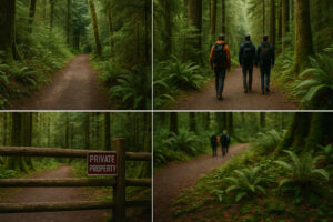
Respect Private Property: Portions of the surrounding land belong to local farms — observe posted signs.
Following these small courtesies helps keep Beaver Valley Falls exactly what it is — a living secret shared in good faith.
Traveler’s Reflection
The first time I visited, it was late October. The sky hung low, the kind of gray that makes colors glow richer. I followed the faint path through damp leaves until I heard the soft hum of falling water. When the falls came into view, it felt like stumbling into someone’s memory — quiet, unguarded, real.
I sat on a log for nearly an hour, watching yellow maple leaves drift slowly into the pool, spin once, then disappear downstream. No one else came. The only movement was the water, steady and self-contained. It felt like the world had stopped, just long enough for me to listen.
Later, when I returned to Port Ludlow, the sound of the falls stayed in my ears — a calm rhythm beneath the noise of daily life. That’s what Beaver Valley Falls gives you: not spectacle, but stillness.
How to Get There
From Port Ludlow: Drive south on Oak Bay Road → turn left onto Center Road toward Chimacum. After roughly 9 miles, look for a gravel pull-off on the right, near mile marker 9. The faint trail begins just beyond the ditch line.
GPS Coordinates: Approx. 47.987° N, -122.765° W.
Distance: About 0.2 mile walk from road to falls.
Difficulty: Easy / moderate due to slippery ground in wet seasons.
Time: 30 minutes round-trip.
If you can’t locate the exact spot, stop by Chimacum Corner Farmstand and ask. Chances are someone will point you in the right direction — after all, the waterfall belongs to everyone who loves it enough to share.
Beyond Beaver Valley
From this quiet nook, water continues its slow journey east toward the sea. Following its path will lead you deeper into the peninsula’s wilder terrain, where streams gather force and cliffs rise higher.
Next, we’ll travel west toward Falls View Canyon near Dosewallips State Park — a place where the landscape shifts from whisper to thunder, and the falls leap through rock like a living storm.
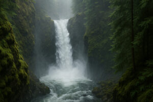
Falls View Canyon – Roaring Beauty in Dosewallips
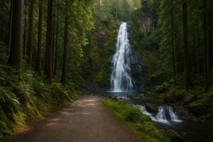
If Ludlow Falls is a whisper and Beaver Valley Falls is a song, then Falls View Canyon is an anthem.
Tucked deep within Dosewallips State Park, just under an hour’s drive from Port Ludlow, this waterfall is where the peninsula’s quiet streams turn wild — where the gentle rhythm of creeks becomes a thunder that shakes the earth and fills the air with mist.
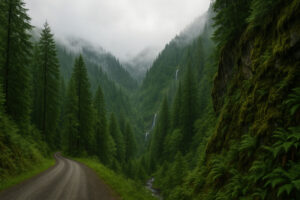
This is not the kind of hidden waterfall you stumble upon accidentally. You have to seek it. The road that leads here winds west through Brinnon, then curves inland into a forest so thick that sunlight seems to fall in liquid beams. Ferns as tall as your shoulders line the shoulders of the road, and the air grows cooler with every mile. Then, just when you think you’ve gone too far, a small wooden sign marked “Falls View Campground” appears beside the trees.
Follow it, and you’ll find one of the most breathtaking waterfall overlooks in Jefferson County.
The Setting: Where Mountains and Rivers Meet
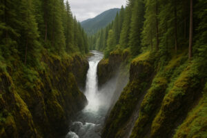
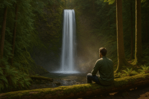
The Dosewallips River begins high in the Olympic Mountains, carving its way through glacial valleys before joining Hood Canal. Falls View Canyon marks one of its most dramatic points — a 75-foot waterfall dropping into a chasm so narrow that mist rises in clouds.
From the upper viewpoint, the river looks like a silver ribbon disappearing into the trees. The sound reaches you before the sight — a low, rolling roar that grows into a steady drumbeat as you approach the edge. When you finally look down, it’s impossible not to feel small.
The waterfall doesn’t fall straight; it tumbles and twists, splitting into sheets that crash against rock ledges before merging again at the bottom. In spring, the force of the water sends spray all the way up to the overlook, coating everything in a fine mist.
The Falls View Trail
There are two ways to experience the canyon: the Overlook Trail and the Lower Trail.
Overlook Trail: A short, well-maintained path (about 0.3 miles round trip) leading to a fenced viewpoint. Ideal for families or anyone wanting a quick, dramatic view without a strenuous climb.
Lower Trail: A steeper descent into the canyon, about 0.8 miles round trip, leading to the riverbank. It’s muddy after rain and can be slippery, but the reward is unmatched — you’ll stand right beside the churning water, close enough to feel its breath.
Both trails start from the small parking area near the campground entrance, where picnic tables and restrooms make it an easy half-day trip from Port Ludlow.
A Symphony of Mist and Sound
Standing at the lower viewpoint, you realize why this place carries such reverence among locals. The air hums with vibration. The water doesn’t just move — it performs. Every splash and rebound against stone creates a deep, resonant rhythm that fills the entire canyon.
It’s a place where you stop talking instinctively. The sound commands silence — not from intimidation, but from awe. You find yourself breathing slower, letting the noise wash through you like a heartbeat you’d forgotten you shared with the earth.
In spring, the spray turns to rain on your skin. In summer, sunlight refracts through droplets, creating brief rainbows that vanish as quickly as they appear. By autumn, the roar softens, and you can hear the river’s tone change — less percussion, more melody.
Geology of a Living Canyon
Falls View Canyon is a masterpiece of erosion. Over thousands of years, the Dosewallips River carved its path through basalt and sandstone, sculpting terraces and ridges that still shift subtly each season.
Boulders near the base show signs of past floods, some covered in moss older than most of the trees around them. The canyon walls themselves are layered like pages of a book — each stratum telling a story of volcanic origins, glacial retreat, and relentless water.
This geological diversity makes the area a quiet classroom for naturalists. It’s not unusual to find geology students or park rangers explaining how rainfall patterns and soil composition shape the river’s course — even small shifts upstream can change the waterfall’s flow patterns over time.
Seasonal Personalities
Spring: Explosive flow and roaring energy. The water churns white and cold, and mist fills the air. The surrounding forest glows neon green with new moss.
Summer: Clear skies reveal turquoise pools below the falls. The lower trail becomes more accessible, ideal for sitting near the rocks and watching sunlight move across the canyon.
Autumn: The trees along the rim turn gold, and the waterfall reflects the warm color of the leaves. Morning fog often drifts through the canyon, making for cinematic photos.
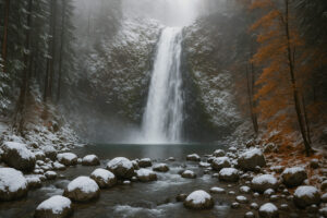
Winter: Fewer visitors, quieter atmosphere. Snow sometimes dusts the upper ridges, and the falls take on a silvery sheen. Bring waterproof gear — it’s wetter and colder, but also deeply peaceful.
Photography & Viewing Tips
Falls View is one of the most photogenic natural sites near Port Ludlow.
Golden Hours: Early morning or late afternoon gives soft light that enhances the mist and color depth.
Tripod & Long Exposure: Capture the silky motion of the waterfall — just protect your gear from spray.
Perspective Shot: The canyon depth creates dramatic vertical compositions; use the guardrail as foreground.
Drone Caution: Not recommended — park rules restrict usage near the river due to wildlife disturbance.
Bring a microfiber cloth — your lens will get misted constantly.
Local Legend: The Roaring Guardian
According to early homesteader stories passed through Brinnon families, the locals once called the waterfall “The Roaring Guardian.”
They believed the sound protected the valley — when the waterfall roared louder than usual, it meant storms were coming, warning farmers and fishermen to prepare.
Though no scientific link exists between waterfall volume and weather, anyone who’s visited during heavy rain will admit: the roar does change. The entire forest seems to vibrate, like nature clearing its throat before a downpour.
It’s easy to imagine why people once felt the falls were alive — here, water isn’t background noise; it’s presence.
Combining the Visit
Because Falls View Canyon lies within Dosewallips State Park, it’s easy to combine your waterfall adventure with other natural highlights:
Dosewallips River Trail: A 5.5-mile route following the river upstream through mossy woods and old-growth cedar.
Rocky Brook Falls: Just 10 minutes away by car — one of the peninsula’s most photogenic hidden gems.
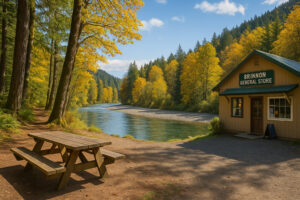
Brinnon General Store: A rustic stop for coffee, snacks, or local souvenirs before heading back to Port Ludlow.
If you enjoy camping, Falls View Campground offers forested sites that let you fall asleep to the sound of rushing water — an experience few places can match.
Practical Information
Location: Dosewallips State Park, Brinnon, WA
Driving Time from Port Ludlow: ≈ 55 minutes via WA-19 S and US-101 N
Trail Length: 0.3 mi (Overlook), 0.8 mi (Lower Trail)
Difficulty: Easy to Moderate (steep in places)
Facilities: Picnic tables, restrooms, limited parking
Fee: Washington State Discover Pass required
Traveler’s Reflection
The first time I stood at the lower overlook, it felt like standing inside a heartbeat. Every vibration from the falls seemed to move through my chest. Mist gathered in my hair, and I could barely hear my own breath. But in that noise — that endless, steady thunder — there was a kind of peace I hadn’t expected.
I realized something that day: silence isn’t the only form of calm. Sometimes, the wildest places bring the deepest quiet within.
When I finally climbed back up the trail, my shoes soaked and my camera full of blurred, beautiful shots, I looked back once more. The waterfall didn’t seem to be saying goodbye — it just kept roaring, reminding me that wonder doesn’t end when you leave.
Next in Our Journey
From Falls View Canyon, we’ll continue deeper into the forest toward Murhut Falls, another two-tiered masterpiece hidden along the Duckabush River Road.
It’s less thunderous, more graceful — a waterfall that feels like poetry written in motion.
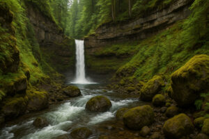
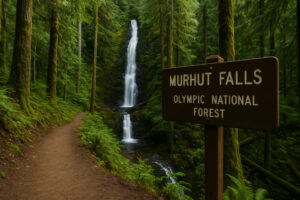
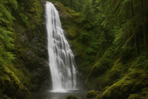
Murhut Falls – Two-Tiered Cascade in the Woods
If Falls View Canyon is raw energy and thunder, then Murhut Falls is elegance in motion — a waterfall that feels more like a dancer than a force of nature. Hidden deep within the Duckabush River Valley, roughly an hour and fifteen minutes from Port Ludlow, Murhut is one of those rare places that manages to feel both grand and intimate at the same time.
The drive alone sets the mood. From Brinnon, you’ll turn west onto Duckabush River Road, a winding route that narrows gradually into forest. With each mile, the canopy thickens, branches arching overhead until sunlight filters through in emerald streaks. The pavement gives way to gravel, the air grows heavy with pine, and the world seems to fold inward into silence — broken only by the murmur of distant water.
You’ll know you’re close when you hear it — that subtle, echoing rumble that means something magnificent is near.
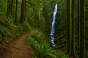
The Murhut Falls Trail is about 1.6 miles round trip, an easy-to-moderate hike that winds through lush second-growth forest. The path is well-maintained but climbs steadily, gaining around 300 feet in elevation before opening to a breathtaking view.
It’s one of those trails where every step feels alive. Ferns brush your legs, moss carpets fallen logs, and the scent of rain seems constant — even on dry days. Birds flit between branches, and you’ll occasionally spot the faint glimmer of sunlight reflecting off unseen water somewhere downhill.
Then, as the path turns sharply left, you hear it: a deep, rhythmic rush. A few more steps, and suddenly the forest opens to a natural amphitheater — a high rock wall streaked with green and white, and in the center, water tumbling in two perfect stages.
This is Murhut Falls, one of the Olympic Peninsula’s most photogenic hidden gems.
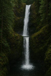
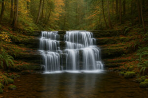
The Two-Tiered Wonder
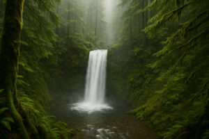
The upper tier of Murhut Falls drops about 40 feet, sliding gracefully over a smooth cliff face. The lower tier plunges another 60 feet into a dark, mossy pool, creating clouds of mist that rise like smoke through the trees.
Together, the two levels give the impression of a waterfall that flows straight from the sky — tall, slender, and endlessly graceful. When sunlight hits it, the entire cascade gleams silver-white against the shadowed cliff, like a ribbon unraveling in slow motion.
Unlike Falls View Canyon, Murhut is quieter — not in volume, but in mood. The sound is softer, more layered, echoing gently through the narrow valley. It feels less like a roar and more like a conversation between stone and air.

A Photographer’s Dream
Murhut Falls is one of those rare natural subjects that seems incapable of looking bad. Still, there are a few tricks that reveal its best angles:
Arrive Early: Morning light streams diagonally across the falls, illuminating the mist and highlighting both tiers evenly.
Bring a Wide Lens: The upper tier is high enough that a full view requires a wide frame — 16–24 mm range works best.
Use a Tripod: Long exposures at ¼–1 second capture the waterfall’s silk-like flow.
Frame with Ferns: Mossy foregrounds add depth and scale to your shots.
A few natural ledges along the trail offer safe vantage points, but stay clear of wet rocks near the edge — they can be deceptively slick, even on sunny days.
Seasons of Beauty
Spring: The falls thunder with life, fueled by snowmelt from the Olympic Mountains. Expect spray so heavy you’ll feel it on your face long before you reach the viewpoint.
Summer: The flow slows slightly, revealing hidden rock textures beneath the water. Sunbeams dance across the pool, and butterflies often drift through the clearing.
Autumn: Fallen leaves float in slow circles around the base of the falls. The golden foliage above creates a warm glow against the cool stone.
Winter: Mist hangs thick, and the trail takes on a moody, timeless quiet. When temperatures dip, icicles form along the cliff edges — transforming the falls into a frozen sculpture of glass and silver.
Each season has its voice, and Murhut whispers them all in rhythm.
Locals sometimes talk about a “third fall” hidden above the main two tiers — a smaller, unseen cascade that feeds the system from a narrow gorge upstream. While not visible from the main trail, it’s part of the same hydrological network that threads through the Duckabush River watershed.
According to long-time hikers in the Brinnon area, the small upper pool was once used by early settlers as a cool-water rest stop during logging trips. They’d refill canteens, cool their hands, and listen to the echoing water that seemed to pulse with the mountain’s breath.
Today, that same sense of wonder lingers. You don’t need to see the upper pool to feel its presence — the steady vibration beneath your feet reminds you that it’s there, feeding the flow just beyond sight.
Getting There
From Port Ludlow:
Take WA-19 S to WA-104 W.
Merge onto US-101 N toward Brinnon.
After passing Brinnon, turn left onto Duckabush River Road (signposted).
Follow for about 6 miles until you reach the trailhead parking area.
Trailhead Coordinates: 47.711° N, -122.998° W
Round-Trip Distance: 1.6 miles
Elevation Gain: 300 ft
Difficulty: Easy–Moderate
Facilities: Small gravel lot; no restrooms — nearest are at Dosewallips State Park.
Fee: None (no pass required at time of writing).
Allow 1.5 to 2 hours for a leisurely visit.
Nearby Stops
Duckabush River Access: A tranquil picnic area along the river, perfect for a post-hike break.
Brinnon General Store: Refuel with coffee or local snacks.
Dosewallips State Park: Just 15 minutes away — great for combining multiple waterfall visits.
Those staying overnight might consider the cozy Mount Walker Inn or a cabin rental near Brinnon, both offering rustic comfort close to the trail network.
Responsible Exploration
Murhut Falls sits within Olympic National Forest, a protected area managed for both recreation and conservation. That means respecting its fragility is essential.
Stay on the main trail: The soil near the waterfall is loose and erodes easily.
Avoid climbing the rocks: Tempting, but dangerous — slippery even in dry weather.
Take only photos: No stacking stones or leaving tokens; let nature keep its design.
Visit off-peak hours: Early morning or weekday afternoons ensure a quieter, less crowded experience.
These small acts of respect help preserve the waterfall’s wild character for everyone who follows.
Traveler’s Reflection
The first time I stood in front of Murhut Falls, I didn’t speak for a long time. The water fell so smoothly it looked like a thread of light, like silk pulled from the mountain’s heart. The mist rose gently, catching sunlight in a faint prism.
I sat on a fallen log and just watched. The sound wasn’t a roar or a crash — it was a rhythm. A heartbeat. The longer I stayed, the more I realized that this place wasn’t just about sight or sound — it was about patience.
Murhut Falls doesn’t ask for admiration; it rewards attention. It’s the kind of place that teaches you to slow down until time feels irrelevant — where every drop of water feels like a new beginning.
When I finally turned back toward the trail, I noticed something I’d missed before: the quiet echo of another small fall further upstream. It wasn’t visible, but I could hear it faintly, a promise that the forest still held more secrets.
Moving Forward
From Murhut Falls, our journey follows the flow northward to Rocky Brook Falls, one of the most celebrated — yet surprisingly uncrowded — waterfalls on the Olympic Peninsula.
Where Murhut whispers, Rocky Brook sings.
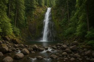
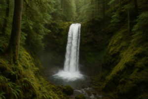
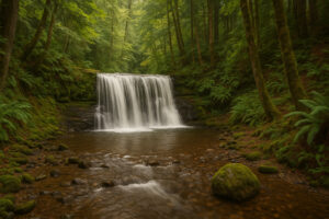
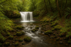
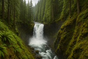
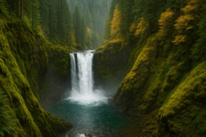
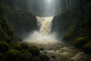
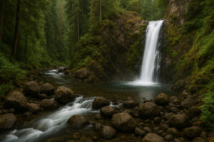
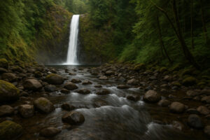
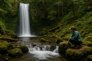
Some waterfalls demand effort — long trails, remote forest roads, hours of planning. Rocky Brook Falls is not one of them. Tucked quietly off US-101 near Brinnon, just under an hour from Port Ludlow, this 229-foot waterfall feels like an unexpected gift — powerful, photogenic, and remarkably easy to reach.
It’s the kind of hidden gem that locals love to mention only in passing, as if trying to keep it for themselves. But once you’ve seen it, you’ll understand why.
The sound of the falls reaches you before the sight does — a deep, rhythmic rush echoing through the trees. Then, as you round the final bend, the forest parts like a curtain, and there it is: a single, magnificent cascade pouring down a vertical wall of moss-covered basalt. The water falls uninterrupted, gathering in a broad pool before continuing downstream through a boulder-filled creek.
It’s dramatic yet serene — wild but somehow welcoming.
The Short Trail with Big Reward
Reaching Rocky Brook Falls couldn’t be easier. The trail begins right off Dosewallips Road, just two miles west of Brinnon. A small gravel parking pullout sits beside a gated utility road that follows the creek for about a quarter-mile.
The path is wide, flat, and shaded — more a leisurely stroll than a hike. The sound of running water accompanies you the entire way, growing louder until it drowns out conversation. The trail ends at a clearing where the falls dominate the scene, framed by tall evergreens and stone cliffs that glow green with moss and rain.
The accessibility makes this spot perfect for families, photographers, or travelers with limited time. Yet despite its proximity to the highway, it still feels hidden — protected by forest and silence.

First Impressions
The first thing that strikes you is scale. At 229 feet, Rocky Brook Falls is the tallest easily accessible waterfall on the eastern side of the Olympic Peninsula. Water plunges from a cliff shaped like a natural amphitheater, scattering mist that drifts outward like breath.
The second thing you notice is how alive the place feels. Even on still days, the air moves — carried by the sheer energy of falling water. Ferns tremble, droplets shimmer on your clothes, and the faint scent of minerals mixes with cedar.
If you arrive early, sunlight breaks through the treetops and paints the spray gold. By midday, the entire canyon glows — a living mosaic of stone, water, and light.
Seasons of Splendor
Spring: Snowmelt from the Olympics transforms the falls into a roaring column, filling the air with thunder and mist. Bring a rain jacket — you’ll get soaked standing near the base.
Summer: The flow calms slightly, revealing intricate rock patterns behind the falling water. This is the best time for photos and picnics by the pool.
Autumn: Leaves from maples and alders collect on wet boulders, turning the entire scene into a painting of copper and gold. Morning fog adds a layer of mystery.
Winter: The falls become a curtain of glass — sometimes partially frozen, with ice shelves glinting along the edges. It’s quieter, colder, and hauntingly beautiful.
Photography Tips
Rocky Brook Falls is one of the most photogenic spots on the Olympic Peninsula. You could stand here all day and never take the same photo twice.
Tripod Recommended: Long exposures (½–1 second) capture the waterfall’s silk-like movement.
Best Time: Morning for soft light, late afternoon for shadows that emphasize texture.
Foreground Interest: Use boulders or reflections in the pool to frame your shot.
Don’t Forget Vertical Shots: The sheer height of the falls demands portrait orientation to capture its scale.
Watch for Spray: The mist is constant; keep a lens cloth handy.
For drone photographers (where permitted), the aerial view reveals the full length of the cascade flowing into the forest beyond — but always confirm current restrictions before flying.
The Human Story Behind the Falls
Long before it became a hidden favorite among travelers, Rocky Brook was part of the Brinnon Hydroelectric Project, a small utility system built in the early 20th century to generate local power. A portion of the creek’s flow still feeds through a small penstock higher upstream.
Despite this history of development, the natural beauty of the falls remains untouched. Locals often say it’s a rare example of balance — where human use and wilderness coexist respectfully.
In fact, many longtime residents recall picnicking here as children, long before social media made it “discovered.” It remains a beloved weekend stop for Jefferson County families, proof that you don’t need to go far to find magic.
Swimming and Safety
During summer, when the water level drops, the wide pool at the base of Rocky Brook Falls becomes a popular wading and swimming spot. The clear, cold water makes for an invigorating dip after hiking nearby trails like Murhut Falls or Dosewallips River Trail.
However, conditions vary with rainfall and snowmelt. The rocks around the pool are extremely slippery, and the current can surge unexpectedly. If you plan to enter the water:
Stay close to the shallow edges.
Never climb the rocks behind or beside the falls.
Wear grippy footwear, not flip-flops.
Avoid swimming during spring runoff or after heavy rain.
Even from a safe distance, the sound and mist create an immersive experience — like standing inside the rhythm of nature.
Picnic and Rest Areas
There are no official picnic tables here, but smooth boulders near the creek make perfect seats. Bring a thermos of coffee or a packed lunch and stay awhile — you’ll notice how the atmosphere shifts constantly as light and wind change.
If you prefer facilities, Dosewallips State Park (five minutes away) offers picnic areas, restrooms, and shaded lawns beside the river — ideal for combining both sites in a single afternoon.
Getting There
From Port Ludlow:
Head south on Oak Bay Road and merge onto WA-104 W.
Join US-101 N toward Brinnon.
Pass through Brinnon and turn left onto Dosewallips Road.
After about 2 miles, look for a gravel pullout on the right near a small utility building — that’s the start of the trail.
Trail Details:
Length: 0.5 miles round trip
Elevation Gain: Minimal
Difficulty: Easy
Facilities: None at site; restrooms available at Dosewallips State Park
Fee: None (public access)
Allow at least 45 minutes to enjoy the site without rushing.
Local Tips
Arrive early to avoid crowds — especially on weekends.
Bring a light rain shell even in summer; the mist keeps the air cool.
Combine your visit with lunch at Geoduck Restaurant & Lounge in Brinnon — a classic waterfront spot with unbeatable Hood Canal views.
Stop by Dosewallips River Delta afterward to watch eagles and seals at play.
For those staying in Port Ludlow, visiting Rocky Brook makes for a perfect day trip loop with Murhut Falls and Falls View Canyon, all reachable within a single scenic drive.

Traveler’s Reflection
I arrived at Rocky Brook just after sunrise. The air smelled like pine and rain, and a soft haze hung between the trees. As I walked the short path, the roar of the waterfall grew louder until it filled everything — air, body, thought.
Standing at the base, I felt the spray hit my face and the sound press through my chest. It wasn’t frightening; it was cleansing — like being reminded how small and alive you are all at once.
I stayed there longer than I’d planned. Each minute, the light changed, the mist thickened, and the waterfall seemed to breathe differently. By the time I left, the sound had woven itself into memory — the kind that stays with you long after silence returns.
From Here, the Journey Continues
As water from Rocky Brook races toward Hood Canal, it joins a network of streams that connect nearly every corner of the peninsula — proof that each hidden waterfall is part of a larger, living story.
In the next part of our journey, we’ll wander beyond the famous names and explore the lesser-known microfalls and seasonal streams that dot the forests around Port Ludlow — the quiet flows that most maps forget but nature never does.
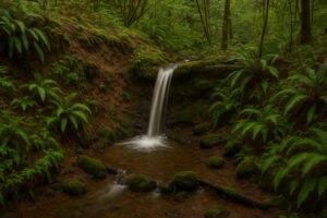
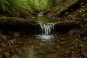
Exploring Lesser-Known Streams & Microfalls
Not every waterfall thunders.
Some whisper, some sing so softly that you have to lean in to hear them. Around Port Ludlow, those whispers come from dozens of unnamed creeks that run through the forest after rain, carving temporary veins of silver into moss and stone. They’re the unsung members of the Olympic Peninsula’s waterfall family — small, fleeting, and utterly magical when you find them.
Locals call them “microfalls.” Some flow only a few weeks each year; others return with every storm. They rarely appear on maps, but they add texture to the landscape and reveal the quiet side of the region’s hydrology. Finding them is less about directions and more about intuition — following sound, shade, and the scent of wet earth.
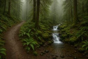
Just a few miles south of Port Ludlow lies Teal Lake, a tranquil spot beloved for its loop trail and birdsong. Feeding that lake is Teal Creek, a narrow stream that winds through dense understory before spilling into a series of miniature falls. After spring rain, the creek transforms into a string of pearls — small drops no more than two or three feet high, each one catching sunlight through branches.
The trail crosses the creek several times on wooden bridges, and from each one you can hear the gentle rush of water just below. If you pause and look carefully, you’ll see tiny cascades folding around roots and stones like liquid lace. They may not make the postcards, but they hold a quiet intimacy that lingers long after you leave.
Best season: March to June, when rainfall keeps the flow steady.
Access: Teal Lake Loop Trail, via Olympic Terrace Road.
Anderson Lake State Park — Ephemeral Water Wonders
To the southwest, Anderson Lake State Park hosts a network of wooded paths that come alive with seasonal runoff. During wet months, the trail edges fill with thin ribbons of water that slip over muddy ledges and vanish into ferns. These microfalls may be temporary, but they add music to the forest — soft notes that accompany the calls of warblers and frogs.
On quiet days you can trace the sound back to its source — a small hollow in the earth where rainwater collects and spills over roots like a miniature version of the peninsula’s grander cascades. It’s a reminder that the same forces that shaped Rocky Brook and Murhut are always at work, even in the smallest corners.
Pro tip: Visit after a spring shower and wear boots — you’ll find waterfalls where you least expect them.
Highway 101 Roadside Surprises
Travelers heading north from Brinnon toward Quilcene sometimes notice glimmers of water between trees. Several unnamed streams descend from the foothills above the highway, forming ephemeral falls visible only from the shoulder. They last days after heavy rain and disappear as quickly as they arrive.
One of the most reliable appears just south of Mount Walker Viewpoint, spilling about 15 feet down a mossy embankment. It doesn’t have a name, but it often stops drivers in their tracks. If you pull over, do so safely — there’s a small gravel turnout with space for two cars — and listen to how the traffic noise melts into the water’s rhythm.
Local nickname: “The Blink Fall” — because you’ll miss it if you blink.
Forest Drainages near Ludlow Bay
Closer to town, small runoff channels feed into Ludlow Bay, forming tiny seasonal falls along the edge of the trail network. After autumn storms, you can find them on the Beach Club Trail and Harbormaster Loop. They’re no taller than a person, but their sound fills the air with a gentle pulse that mixes with the distant clink of sailboat rigging in the marina.
Locals often walk these paths in the evening, when the light turns amber and the forest seems to hum. It’s an easy way to feel immersed in the region’s water story without leaving town.
The Science of Small Waterfalls
Microfalls might look delicate, but they play a critical role in the ecosystem. By slowing the flow of rainwater, they reduce erosion and allow sediment to settle — which helps filter the water before it reaches larger streams. The pools they create support insects, frogs, and songbirds that depend on shallow water habitats.
Scientists from Jefferson County Conservation District occasionally monitor these tiny channels to study how rainfall patterns shift with climate change. Their findings show that small creeks react first — drying earlier in summer and returning faster in autumn. It’s another reason to protect forest cover and keep runoff natural.
The beauty of microfalls is that you don’t need a map — you just need to slow down and pay attention.
Listen first: Water always betrays its presence by sound. Turn off music and open a car window as you drive forest roads.
Look for green: Brighter, denser vegetation often marks damp ground and seasonal flow.
Check after rain: Wait a day or two after a storm when creeks are full but safe to approach.
Bring rubber-soled boots: These areas are muddy, even in sunshine.
Respect private land: Many of these streams cross through residential greenbelts — stay on public trails.
You’ll soon realize how alive the land really is — how even the quietest valley is always in motion.
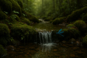
Microfalls as Mindfulness
There’s a different kind of peace in watching a tiny stream instead of a towering cascade. You notice details you’d miss at a larger site — the way water threads through moss, the flash of a dragonfly hovering just above the surface, the ring a single drop makes when it lands.
Many locals treat these microfalls as personal sanctuaries. They walk to them during lunch breaks or after rainy evenings just to breathe and listen. You can’t help but slow down — the water sets its own pace, and the forest encourages you to match it.

Sketchbook Moments
If you carry a notebook or camera, microfalls are perfect subjects for creative practice. Their subtle shifts in light and movement teach patience and observation. Try to capture the shape of the flow or the way a leaf rides the current — you’ll see how small things can tell big stories.
Local artists often use these hidden creeks as study subjects for larger paintings of the Olympic landscape. One Port Townsend painter once said, “It’s not the size of the waterfall that moves you — it’s the light it carries.”
Responsible Exploration
Because microfalls are fragile, a few simple rules go a long way:
Avoid walking in the streambed. Even shallow footprints can disturb plants and insects.
Don’t build rock stacks. They disrupt the natural flow and can collapse habitats.
Leave branches and logs in place. They create micro-pools that support wildlife.
Pack out everything, especially tissues or food waste — microfalls often flow directly into larger streams.
Treat them like you would a work of art in a museum — look closely, but don’t touch.
Traveler’s Reflection
One rainy afternoon in May, I took a short walk along Teal Lake Loop. The trail was empty, the air soft and blue with mist. Halfway around, I heard something — a quiet trickle, barely audible over the sound of my boots. I followed it through a grove of maples and found a tiny cascade no taller than my knee, sliding over a mossy root into a pool the size of a bowl.
There was nothing grand about it, and yet it was perfect. The water was clear, the air still, and the moment felt infinite. I stood there for minutes, watching bubbles rise and pop, until the rain started again and the little fall grew slightly louder.
When I left, I realized that the joy of waterfalls isn’t always in their height or volume — it’s in their presence. Even the smallest flow can remind you how alive the world is.
Next in Our Journey
From these tiny creeks, we move to practical wisdom — learning the best times to visit and how to stay safe around the Peninsula’s waterfalls. Whether you’re standing beneath Rocky Brook or kneeling beside a Teal Creek microfall, respect and timing make the experience richer and safer for everyone.
Best Time to Visit & Safety Around Waterfalls
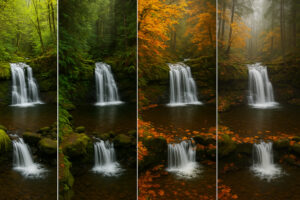
Waterfalls are living things — always changing, always moving. Around Port Ludlow and the Olympic Peninsula, they transform with the rhythm of the seasons: loud in spring, serene in summer, golden in autumn, and ghostlike in winter. Knowing when to visit and how to stay safe makes every experience not only more beautiful but also more meaningful.
Whether you’re chasing the roar of Falls View Canyon or the quiet shimmer of Ludlow Falls, understanding the landscape helps you move through it with respect and confidence.

Spring – The Season of Renewal
Spring is when the waterfalls are at their most powerful. Rain and snowmelt from the Olympic Mountains feed every creek and river, creating spectacular flow. Trails like Murhut Falls and Rocky Brook Falls surge with life, misting everything around them in fine spray.
What to expect:
Lush greenery and moss at peak vibrancy.
Strong currents and slippery rocks.
Occasional trail closures due to washouts — always check local park updates.
Tips:
Wear waterproof boots and a lightweight rain jacket.
Bring a microfiber cloth for your camera lens — mist is constant near the bigger falls.
Visit early morning or late afternoon to catch softer light filtering through the fog.
This is the most photogenic season, when everything feels alive and the forest hums with sound.

Summer – Calm Flows and Easy Access
By June and July, the forest dries slightly, and many waterfalls settle into steady, shimmering ribbons. Trails are more accessible, parking areas open fully, and wildflowers bloom in sunny clearings.
Best for: family trips, photography, picnics, and combining waterfalls with beach visits or kayaking around Hood Canal.
Highlights:
Rocky Brook Falls: safe for wading and photography.
Teal Lake microfalls: clear, reflective water perfect for nature sketches.
Ludlow Falls: shaded retreat on warm afternoons.
Safety reminders:
Even gentle flows can hide slippery algae on rocks — step carefully.
Stay aware of heat and hydration — coastal humidity can disguise dehydration.
If swimming near Rocky Brook or similar pools, avoid climbing rocks or standing directly under the falls.
Summer is when the peninsula feels kindest — everything easy, open, and filled with light.
Autumn – Golden Silence
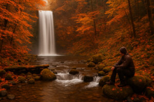
Fall brings fewer visitors and more atmosphere. The forest turns amber and red, and the sound of rain returns after the dry months. Waterfalls become softer but more introspective — a perfect season for quiet travel.
Best for: solitude, reflection, and photography.
Ideal spots:
Beaver Valley Falls: framed by autumn leaves and farm country stillness.
Falls View Canyon: mist mixing with gold foliage for cinematic contrast.
Anderson Lake Park: ephemeral streams reawakening after the first rains.
Tips:
Bring layers — mornings are cool, afternoons mild, evenings damp.
Expect slick trails under falling leaves.
Watch for shorter daylight hours — plan your hikes to finish before dusk.
If spring is the peninsula’s heartbeat, autumn is its breath — slower, deeper, and full of quiet beauty.
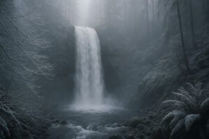
Winter – Mist and Mystery
Winter hiking near Port Ludlow is for those who love solitude. The big waterfalls rarely freeze completely, but their mist thickens, and the surrounding forest glows silver and green. The air feels sharper, the light softer, and every step seems to echo.
Best for: photographers, writers, and travelers who find beauty in stillness.
Waterfalls to visit:
Ludlow Falls: calm, easy to access even in light rain.
Rocky Brook Falls: partially frozen spray creates surreal ice formations.
Falls View Canyon: dramatic flow and heavy mist, best viewed from the upper overlook.
Safety reminders:
Always wear waterproof layers — temperatures can hover near freezing.
Trails can be slick with frost or mud; use trekking poles for balance.
Avoid venturing too close to the water’s edge — currents are stronger than they appear.
Winter reveals the raw soul of the Pacific Northwest — moody, magical, and humbling.
Safety and Respect for the Land
No matter the season, waterfall exploration requires awareness. These landscapes may look gentle, but they’re shaped by power — by forces that deserve respect.
1. Stay on Trails
Leaving marked paths damages roots, erodes soil, and can lead to dangerous footing. If a path looks blocked, wait for park crews to reopen it.
2. Keep a Safe Distance
It’s tempting to get close for a photo, but even small falls can produce strong undertows and slippery rocks. Stand back — the mist and sound will still surround you.
3. Watch for Sudden Water Surges
Heavy rain upstream can raise creek levels in minutes. If the flow starts increasing rapidly, move to higher ground immediately.
4. Carry Essentials
Even short walks deserve preparation: water, snacks, flashlight, small first aid kit, and an offline map. Forest reception can vanish without warning.
5. Respect Wildlife and Silence
Deer, owls, and small mammals rely on these water sources. Move quietly, avoid loud music, and leave no trace. The fewer sounds you make, the more you’ll hear.
How Weather Shapes Experience
The waterfalls around Port Ludlow don’t just look different in each season — they sound different too.
After a storm, the forest is alive with echoes and dripping leaves. On calm summer mornings, you can hear the water’s fine notes — trickles and splashes you might miss otherwise. Fog amplifies everything, turning the woods into a natural cathedral.
Local tip: Some of the most memorable moments happen in light rain, when mist softens edges and every droplet shines like glass. Bring a poncho and enjoy what locals call “liquid sunshine.”

Planning Smart
If you’re visiting multiple waterfalls in one day, plan your route as a loop:
Morning: Start with Ludlow Falls and coffee at Marina Café.
Midday: Drive toward Brinnon to explore Falls View and Rocky Brook.
Afternoon: Stop at Finnriver Cidery or Chimacum Corner for a warm drink and local snacks before returning.
Download maps in advance; GPS signals can fade near forested canyons. The Jefferson County Parks website and Olympic National Forest alerts provide updated trail conditions, especially after winter storms.
Traveler’s Reflection
No two visits to a waterfall are ever the same. One day, it’s roaring and wild, another it’s barely whispering. That’s the magic of chasing waterfalls near Port Ludlow — you never see the same thing twice.
I’ve stood at Ludlow Falls in pouring rain, soaked to the bone but grinning like a child, and I’ve stood there again in late August when the water barely moved but the forest glowed gold in the sun. Both moments felt perfect — because both were honest.
Waterfalls teach patience. They remind us that beauty isn’t static — it’s alive, shifting, and unpredictable. And the more you visit, the more you understand that change is part of the story.

Next in Our Journey
In the final part of this guide, we’ll wrap up our exploration of hidden waterfalls near Port Ludlow with nearby cafés, rest stops, and closing reflections — where to unwind after the trails, and how these waterfalls connect to the spirit of the Olympic Peninsula itself.
Nearby Eats & Rest Stops
Every waterfall leaves you a little hungry — for warmth, for flavor, for a quiet place to sit and let the day settle. Around Port Ludlow, you’ll find cafés, restaurants, and resting spots that match the landscape’s spirit: relaxed, local, and filled with simple comfort.

The Fireside Restaurant – Local Taste by the Marina
Inside The Inn at Port Ludlow, this restaurant overlooks the bay where the forest meets the tide. After a morning at Ludlow Falls, it’s the perfect place to refuel with Dungeness-crab chowder, pan-seared salmon, or a seasonal salad made from Chimacum Valley farms.
Sit by the window, watch sailboats drift past, and listen to the faint echo of waves — a softer version of the sound you just left behind in the woods.
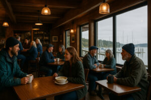
Marina Café & Pub – Casual Coffee and Conversation
Just steps from the docks, the Marina Café & Pub is the town’s social heart. Hikers, sailors, and locals gather here for strong espresso, clam chowder, and stories of where they’ve been that day.
If you still have damp boots or pine needles on your jacket, no one minds — it’s that kind of place.

Finnriver Farm & Cidery – Rural Charm and Cider Flights
A short drive toward Chimacum brings you to Finnriver, where orchard rows stretch across open fields and live folk music fills the air on weekends. Order a cider flight, sit under string lights, and watch the evening mist settle over the valley.
It’s a beautiful way to transition from waterfalls to warmth — nature outside, craftsmanship in your glass.

Geoduck Restaurant & Lounge – Seafood with a View
In nearby Brinnon, overlooking Hood Canal, the Geoduck is a favorite among travelers returning from Rocky Brook Falls or Falls View Canyon. The menu celebrates the sea: oysters, prawns, and chowders served with canal views that glow pink at sunset.
Pair your meal with a local beer and relive the day’s adventures while the tide slides quietly below.

Chimacum Corner Farmstand – Quick Bites on the Way
If you prefer a picnic, stop by Chimacum Corner Farmstand for fresh fruit, cheeses, and pastries. Their cider-glazed apple hand pies and locally brewed kombucha make perfect companions for a stop along the Beach Club Trail or Teal Lake Loop.
Places to Rest and Reflect
After a day of chasing waterfalls, the best reward is stillness — a bench, a view, a moment to breathe.
Bay Club Park: A grassy overlook above the marina, perfect for sketching or journaling.
Ludlow Falls Bench: Sit here in late afternoon when the light softens and watch mist drift through the trees.
Dosewallips State Park Picnic Area: Shaded tables beside the river, ideal between waterfall visits.
Port Ludlow Marina Boardwalk: Sunset strolls here complete the loop between forest and sea.
Each spot feels connected to the others, as if the water you followed all day has simply changed form — from rushing falls to quiet tide.

From Water to Community
What makes the Port Ludlow area special isn’t just its natural beauty but how closely it’s tied to community. The same people who maintain trails at Ludlow Falls or clear debris from Teal Creek also run the cafés, art studios, and local farms you visit afterward.
This shared care keeps the region alive. Hike long enough, and you’ll realize every trail, bridge, and viewpoint exists because someone loved the land enough to protect it.
Building Your Perfect Day Trip
If you have one day to experience the best of Port Ludlow’s waterfalls, here’s a simple route locals recommend:
Morning – Start at Ludlow Falls, then enjoy breakfast at Marina Café.
Midday – Drive to Brinnon and explore Falls View Canyon and Rocky Brook Falls.
Afternoon – Stop at Finnriver Cidery for cider and music on the way back.
Evening – Return to The Fireside Restaurant for dinner and sunset over Hood Canal.
You’ll experience the full spectrum — from quiet forest whispers to coastal reflection — all in a single loop.
What the Falls Teach You
Every waterfall tells a story of patience. It doesn’t rush; it shapes. It carves rock grain by grain, year after year, until something extraordinary appears.
Exploring the hidden waterfalls near Port Ludlow reminds you to move the same way — slowly, deliberately, with awareness. Whether it’s the powerful descent of Rocky Brook, the forest grace of Murhut, or the humble beauty of Beaver Valley, each one teaches something about resilience and change.
Stand close enough, and you’ll feel that lesson seep into your own rhythm.
Final Reflection
At the end of the day, when your boots are muddy and your camera full, pause by the marina and listen. Somewhere far off, the same rain that feeds the waterfalls is falling again — on mountains, on moss, on the roof above you.
That’s the quiet circle that ties everything together here. The waterfalls of Port Ludlow aren’t just places on a map; they’re living moments in an ongoing story of water, forest, and time.
If you leave with one memory, let it be this: the sound of falling water stays with you long after you’ve gone. It follows in the rhythm of the tide, the rush of wind through cedar, even the stillness of your own breath.
Here, the land doesn’t just flow — it remembers. And once you’ve walked among these hidden cascades, so will you.