When it comes to outdoor adventures, New England delivers in every season. But nothing quite beats the magic of hiking to a secluded waterfall, especially when you hear the roar of cascading water before you even see it. As someone who’s laced up their boots and explored dozens of waterfall trails from Vermont to Maine, I can tell you that these hikes offer more than just Instagram-worthy views. They offer peace, power, and a pinch of mystery—all tucked within the wild, green heart of the Northeast.
From easy family-friendly strolls to more rugged, off-the-grid treks, the best waterfall hikes in New England cater to every type of explorer. And trust me, you don’t need to be a hardcore hiker to appreciate the beauty that awaits. I’ve splashed in shallow pools, cooled off under towering falls, and even discovered a few hidden gems that don’t make it onto tourist maps.
This guide isn’t just a list. It’s a curated collection of hikes I’ve either completed personally or scouted through local intel, real TripAdvisor reviews, and official park websites. I’ll also link you to maps, give you on-the-ground advice, and help you plan your next unforgettable hike.
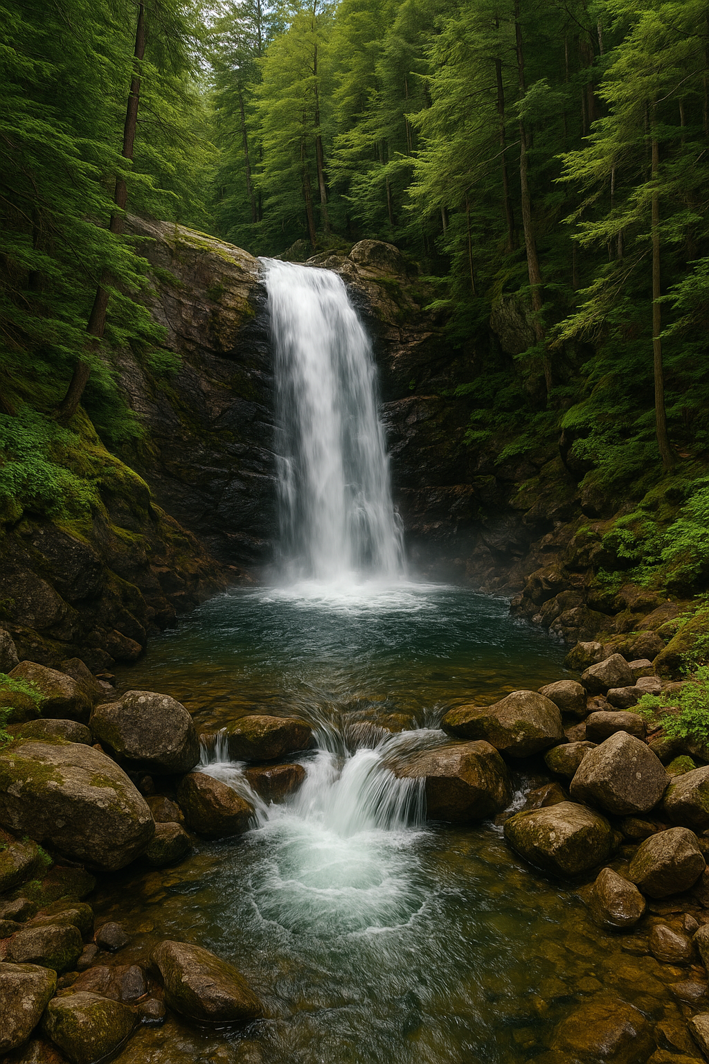
1.Why Arethusa Falls, New Hampshire Is Among the Best Waterfall Hikes in New England
Height: 140 feet
Difficulty: Moderate
Trail Length: 1.5 miles (one way)
Google Maps: Arethusa Falls Trailhead
If there’s one waterfall I never get tired of recommending, it’s Arethusa Falls. Towering at 140 feet, it’s the tallest single-drop waterfall in New Hampshire—and the crown jewel of Crawford Notch State Park.
Best Waterfalls in New England: Your Ultimate Guide to the Most Scenic Waterfalls and Hikes
Why It’s Worth the Hike
Even on a hot summer day, the mist from the falls is refreshingly cool. I’ve hiked this trail multiple times, both solo and with friends, and the vibe changes depending on the season. In early spring, the trail can be muddy, but the waterfall surges with powerful, rushing flow. Come fall, you’ll be rewarded with a cascade framed in gold and crimson leaves.
Trail Experience
The trailhead is easy to find and well-marked. Expect a moderate 1.5-mile trek (one way) with a steady incline. It’s not flat, but it’s not overly steep either—great for intermediate hikers. You’ll cross wooden footbridges, pass smaller streams, and finally, you’ll hear the thunder of the falls just before it comes into view.
If you’re up for more, link this hike with Frankenstein Cliff Trail for a full loop and panoramic mountain views.
TripAdvisor Review
Hike to a beautiful waterfall. It’s 1.5 miles there, so 3 miles roundtrip. Came here in early May and there was still snow. The climb going to the falls was at an incline most of the time, and you should definitely your hiking boots (not sneakers). There’s a parking lot closer to the trailhead; the one that you see off the highway is overflow. $5 parking fee and it’s self-service; you put cash/check in the envelope and deposit it into the payment box. There is one bathroom in the overflow lot. You cross over the train tracks to get to the start of the trail.
— TripAdvisor
2. Why Moss Glen Falls, Vermont Deserves a Spot Among the Best Waterfall Hikes in New England
Location: Stowe, VT
Height: 125 feet
Difficulty: Easy
Trail Length: 0.25 miles
Google Maps: Moss Glen Falls
This might be one of Vermont’s best-kept secrets. Moss Glen Falls is just minutes from downtown Stowe, yet you’ll feel like you’re deep in the wilderness. The 125-foot cascade tumbles in dramatic tiers down mossy rocks, making it a must-see.
What Makes It Special
I visited on a cloudy morning and found the mist and silence almost spiritual. The hike itself is super short—just a quarter-mile—and mostly flat. You can reach a wooden viewing platform or take a steeper side path for a closer (though slightly more slippery) view at the base.
Locals use this spot as a quick nature reset. It’s a perfect stop if you’re touring Vermont and need to stretch your legs.
Photography Tip
Go early in the day to catch the waterfall lit up by the rising sun filtering through the trees. It’s truly magical.
TripAdvisor Review
We ended up visiting this waterfall after seeing reviews that it was an easy hike. It was not an easy hike. The path along the way to the waterfall was flat and pretty easy. We even got to see numerous beaver craverings along the waterbank. In order to see the waterfall, you need to hike up a pretty steep incline. Not easy at all. The views from the top were gorgeous, but I would not do that again. When we got back near the information board at the start of the path, apparently, it mentioned the incline. Should have definitely read that first!
— TripAdvisor
3. Why Bash Bish Falls, Massachusetts Belongs on Your List of the Best Waterfall Hikes in New England
Location: Mount Washington, MA
Height: 60 feet
Difficulty: Moderate
Trail Length: 0.75 miles (from New York trailhead)
Google Maps: Bash Bish Falls
Straddling the MA-NY border, Bash Bish Falls is both the most dramatic and most photographed waterfall in Massachusetts. It’s located within Bash Bish Falls State Park, and the thunderous 60-foot drop ends in a deep emerald pool—no swimming allowed, though!
Why Locals Love It
There are two main ways to hike here. The New York side is a gentler 0.75-mile trail with wide paths and a slow incline. The Massachusetts trail, on the other hand, is shorter but much steeper. I always recommend the NY side unless you enjoy leg-burning climbs.
Come in autumn when the foliage explodes with color—photos don’t do it justice.
Local Tip
Arrive early in the day. This place gets packed, especially on weekends. And bring a picnic—you’ll find tables near the parking lot, and the background sounds of the waterfall make for the perfect lunch soundtrack.
TripAdvisor Review
Bash Bish Falls is beautiful. Specific signs for no swimming as it is dangerous. The walk/hike is was lovely. Don’t miss the iron works restoration close by in Copake Falls, NY
— TripAdvisor
4. Why Angel Falls, Maine Deserves a Spot on the Best Waterfall Hikes in New England List
Location: Township D, ME
Height: 90 feet
Difficulty: Moderate
Trail Length: 1.2 miles
Google Maps: Angel Falls
Tucked away in the western mountains of Maine, Angel Falls is one of the most unique cascades in the region. It’s named because, depending on the water flow, the falls can resemble an angel with outstretched wings.
The Ultimate Guide to the Best Lakes in Vermont
The Adventure to Get There
This is one of those waterfalls you feel like you’ve “earned.” You’ll need to drive a few miles on a gravel logging road, so make sure your car can handle it. The trail itself is a relatively moderate 1.2 miles, with some stream crossings (wear waterproof boots if it’s rained recently).
When I visited in early summer, wildflowers lined the trail and I didn’t see a single other hiker. It’s remote and peaceful.
Bring a Buddy
Because of the remote setting, it’s best to hike with someone else. Cell signal is spotty, but you’ll get GPS navigation to the trailhead just fine with offline maps.
TripAdvisor Review
⭐️⭐️⭐️⭐️⭐️
“A peaceful, hidden treasure. We had the place to ourselves and the view was just magical. Bring bug spray!”
— TripAdvisor
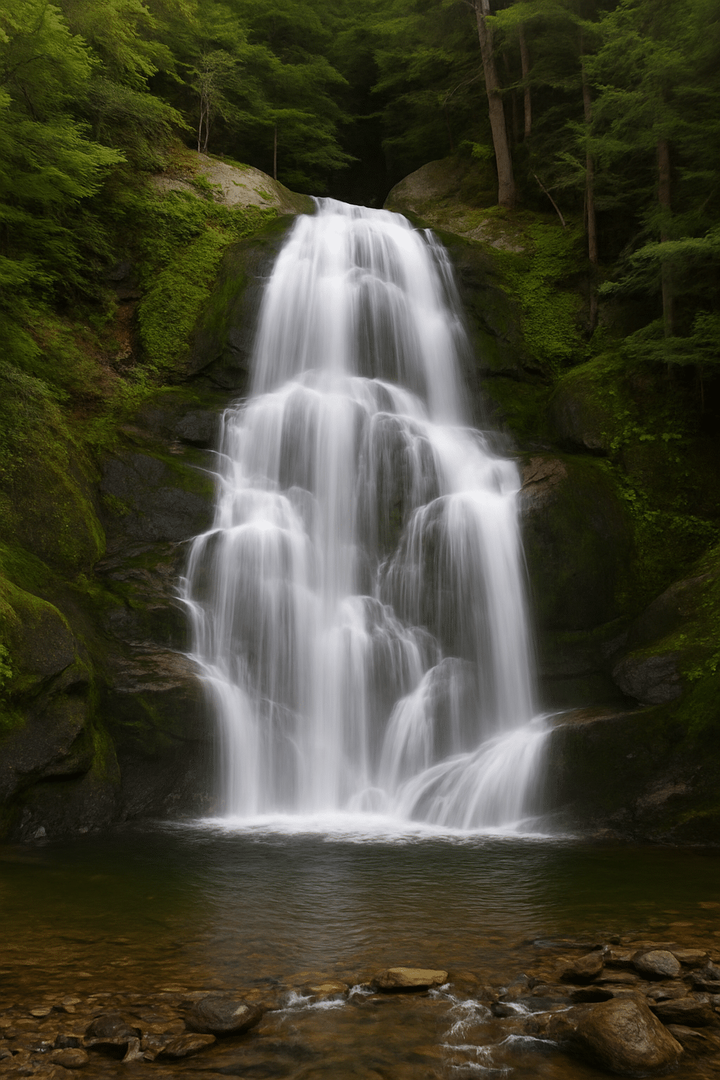
5.Why Kent Falls, Connecticut Deserves a Spot Among the Best Waterfall Hikes in New England
Location: Kent, CT
Height: 250 feet (cascading)
Difficulty: Easy
Trail Length: 0.25 miles
Google Maps: Kent Falls State Park
Located in the heart of Litchfield Hills, Kent Falls is a family favorite and one of Connecticut’s most visited natural landmarks. The falls drop a combined 250 feet through a lush ravine, broken up into several small tiers.
Why It’s Great for Everyone
This is one of the best waterfall hikes in New England if you’re bringing kids, grandparents, or someone who just wants a light stroll. There are stone steps and viewing platforms all the way up, plus plenty of grassy spots for a picnic.
I’ve brought out-of-town guests here several times—it’s always a hit. Prefer quieter spots? Explore our guide to hidden waterfalls in New England.
Pro Tip
Visit early in the morning or late afternoon to avoid the crowds. And bring cash for the parking fee if you’re a non-resident.
TripAdvisor Review
The falls are gorgeous. I didn’t realize how far up they go, which was a pleasant surprise. The hike is not too challenging. It’s lots of steep uphill stairs and climbing up sharp inclines. I was under the weather so didn’t go all the way up, but otherwise would have. Very peaceful and serene!
— TripAdvisor
6. Why You Should Visit Diana’s Baths, New Hampshire for a Classic Waterfall Hike Experience
Location: North Conway, NH
Height: Series of small cascades totaling about 75 feet
Difficulty: Easy
Trail Length: 0.6 miles
Google Maps: na’s BatDiahs Trailhead
Nestled just outside of North Conway in the White Mountains, Diana’s Baths is a dreamy collection of gentle waterfalls and shallow pools spread over smooth granite ledges. It’s an especially popular stop for families and photographers, and for good reason.
What Makes It Unique
Unlike towering single-drop waterfalls, Diana’s Baths features a long stretch of smaller falls and swirling pools. It’s ideal for splashing around on a hot day or just soaking up the soothing sounds of cascading water. I’ve visited several times in late spring when the water is high, and again in early autumn when the crowd thins and the foliage steals the show.
Trail Experience
The 0.6-mile trail is well-maintained and almost completely flat, making it accessible for hikers of all skill levels. It’s a gravel path shaded by towering pines, and you’ll often see families with strollers, photographers with tripods, and dogs trotting alongside.
What to Bring
Water shoes or sandals (for slippery rocks)
A towel or picnic blanket
Snacks or lunch (picnic spots are plentiful)
Local Tip: Visit in the early morning or late afternoon to beat the crowds, especially in summer.
TripAdvisor Review
We’d heard and read so much about Diana’s Baths that it was a “must do” for this vacation. We’d read that parking could be a problem so we got there about 8:45 on a Monday morning. Parking was no problem at that hour. We met just a few hikers on the path to the falls; so it was a delightful hike [about .08 mile] with a wide path with few roots and quite level the whole way. It was a beautiful quiet walk with wonderful scenery, rocks and boulders. Not long after getting to the beginning of the falls, more visitors started appearing and it was getting crowded. If you can climb large boulders, you can do get a picture-perfect views with gorgeous settings all around. This is a great hike and would suggest either early morning or later in the afternoon. It’s only $5, that you pay by credit card and put the sticker on your dashboard. There are two bathrooms there, but they were filthy, just FYI. This is a must-do while in the White Mountains.
— TripAdvisor
7.Why Sabbaday Falls, New Hampshire Deserves a Spot Among the Best Waterfall Hikes in New England
Height: 45 feet
Difficulty: Easy
Trail Length: 0.3 miles
Google Maps: Sabbaday Falls
Right off the legendary Kancamagus Highway, Sabbaday Falls is one of New Hampshire’s most accessible and beautiful waterfalls. It’s just a short walk from the road, yet it feels like a secluded forest sanctuary.
Scenic Beauty in a Short Walk
The falls drop in three tiers through a narrow gorge lined with moss-covered rocks and bordered by a wooden walkway. It’s one of the most photogenic spots in the White Mountains, and the well-maintained trail makes it a great stop during a scenic drive.
When I visited in late September, the fall colors and mist created an ethereal scene that felt straight out of a fantasy novel.
Trail Details
Gravel path with gentle incline
Footbridges and wooden railings for safety
Benches along the way for relaxing
Accessibility
While it’s not fully wheelchair-accessible, many visitors with limited mobility can enjoy the first portion of the trail and view parts of the waterfall from a di
8. Why Chapman Falls, Connecticut Belongs on Your List of the Best Waterfall Hikes in New England
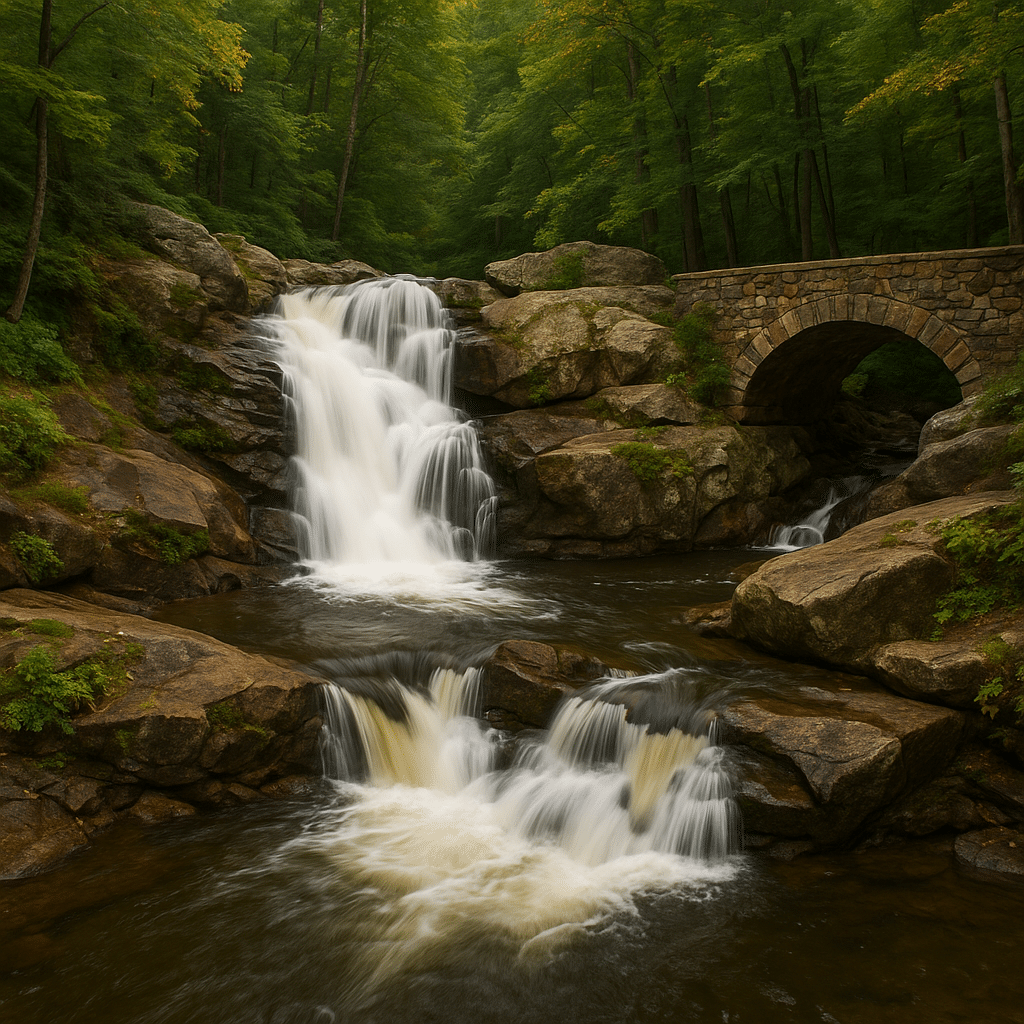
Location: Devil’s Hopyard State Park, CT
Height: 60 feet (multi-tiered)
Difficulty: Easy
Trail Length: 0.5 miles
Google Maps: Chapman Falls
Located in the heart of Devil’s Hopyard State Park, Chapman Falls is a stunning multi-tiered waterfall that flows dramatically over smooth basalt rock. The setting is serene, and the falls are surrounded by hiking trails, picnic areas, and historic stone bridges.
A Peaceful Getaway
I visited Chapman Falls during a spring road trip through Connecticut. The water was gushing, the forest was lush, and I only encountered a handful of other hikers. The falls make a beautiful first impression and are easy to reach via a short trail from the main parking area.
Things to Do Nearby
Explore covered bridges
Hike the park’s trails
Picnic along Eightmile River
Local Legend:
According to lore, the potholes in the rocks near the falls were created by the devil himself stomping around in anger—hence the park’s eerie name!
List of Ski Resorts in Vermont: Your Ultimate Guide to Vermont’s Best Slopes
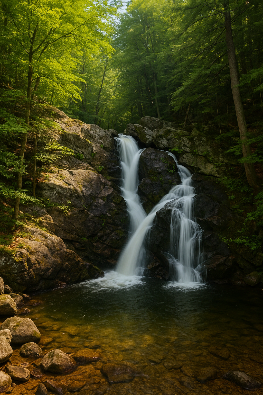
9. Why Bingham Falls, Vermont Belongs on Your List of the Best Waterfall Hikes in New England
Location: Smugglers Notch State Park, VT
Height: 25 feet
Difficulty: Moderate
Trail Length: 0.5 miles
Google Maps: Bingham Falls
One of my favorite quick detours when I’m in the Stowe area, Bingham Falls offers a short but moderately challenging hike that leads to a deep pool perfect for wading and photography. It may not be the tallest, but it’s among the most photogenic.
Best Fall Foliage Routes in New England: Discover the Ultimate Leaf-Peeping Drives
Trail Vibe
The trail descends steeply toward the falls and includes rocky steps that can get slippery when wet. Take it slow, especially if you’re wearing sandals or carrying gear. At the bottom, you’re rewarded with a view of clear, rushing water cutting through steep rock walls.
In summer, you’ll often see locals cooling off in the pool. But be careful—diving isn’t recommended due to hidden rocks.
When to Visit
Spring and early summer offer the best water flow. Fall is quieter and offers gorgeous foliage, but the rocks can be slick with fallen leaves.
TripAdvisor Review
These falls are well worth the trip. The trail is in good shape but people with mobility issues should avoid it as you have to traverse some steep rocks at the end get to the falls. Would Not recommend in rainy weather. We were told there is a second longer trail that is much flatter and easier to traverse but it starts at a different trail head and is longer and goes to the opposite side of the falls. Recommend hiking boots and hiking sticks for climb back up.
— TripAdvisor
10. Why Glen Ellis Falls, New Hampshire Deserves a Spot on the Best Waterfall Hikes in New England List
Location: Pinkham Notch, NH
Height: 64 feet
Difficulty: Easy
Trail Length: 0.3 miles
Google Maps: Glen Ellis Falls
Tucked just off Route 16 in Pinkham Notch, Glen Ellis Falls delivers big beauty with minimal effort. The short hike down to the viewing area offers one of the most rewarding waterfalls-to-effort ratios in New England.
Trail Details
After a short walk from the parking area, you’ll descend a staircase that winds through forest and past smaller cascades. At the bottom, the 64-foot waterfall crashes into a deep pool surrounded by towering rock walls. It’s loud, powerful, and awe-inspiring.
When I visited on a humid summer day, the spray from the waterfall was like nature’s own air conditioning. Bring your camera—it’s photogenic from every angle.
Safety Tip
The steps can get slippery, especially after rain. Hold onto the railings and wear grippy footwear.
Spring (April to June) offers the most powerful flows due to snowmelt, while fall (late September to October) provides spectacular foliage. Summer is best for swimming and wading.
Yes! Many, like Kent Falls, Diana’s Baths, and Moss Glen Falls, are short and family-friendly. Always check trail difficulty before heading out.
Most trails are open to the public and don’t require permits. However, some state parks may charge a parking fee, especially for out-of-state visitors.
Some spots like Diana’s Baths and Bingham Falls have wading areas. Others, like Bash Bish Falls, prohibit swimming due to safety concerns. Always check posted signs.
Use the Google Maps links provided above. You can also download offline maps or trail apps like AllTrails for GPS support in low-signal areas.